|
search place name
|
||
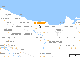
El Peñón (Monte Cristi, Dominican Republic)El Peñón is a town in the Monte Cristi region of Dominican Republic. An overview map of the region around El Peñón is displayed below.
regional and 3d topo map of El Peñón, Dominican Republic ::
El Peñón airports ::
The nearest airport is POP - Puerto Plata Gregorio Luperon Intl, located 78.5 km east of El Peñón.
Other airports nearby include STI - Santiago Cibao Intl (87.4 km south east), CAP - Cap Haitien Intl (92.5 km west), PAP - Port-au-prince Toussaint Louverture Intl (171.1 km south west), BRX - Barahona Maria Montez Intl (174.5 km south), Nearby towns ::
El Cayal (1.7km west) //
Higüerito (2.5km north east) //
El Copey (2.5km south east) //
Sabana Cruz (5.2km west) //
Estero Balsa (5.2km east) //
Puerto Juanita (5.2km east) //
Los Limones (5.6km south) //
Los Jobos (6.4km south west) //
El Guayo (6.6km south east) //
Los Algodones (7.0km west) //
Los Uveros (7.0km west) //
Los Conucos (7.2km west) //
El Papayo (7.2km east) //
Agua de la Palma (10.2km south east) //
[all distances 'as the bird flies' and approximate] 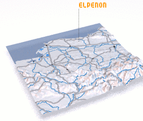 Places with similar names to El Peñón, Dominican Republic ::
Disclaimer :: Information on this page comes without warranty of any kind |
||
|
Where is El Peñón? Elevation and coordinates ::
Latitude (lat): 19°49'0"N Longitude (lon): 71°19'0"W
Elevation (approx.): 184m (map arrows pan, magnifying glasses zoom) |
||
|
Visiting El Peñón? Hotel/Accommodation ::
Book a hotel in El Peñón Travel Guide ::
rental cars ::
car rental offers GPS waypoint ::
download a GPX waypoint (PoI) of El Peñón for your GPS receiver
|
||