|
search place name
|
||
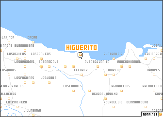
Higüerito (Monte Cristi, Dominican Republic)Higüerito is a town in the Monte Cristi region of Dominican Republic. An overview map of the region around Higüerito is displayed below.
regional and 3d topo map of Higüerito, Dominican Republic ::
Higüerito airports ::
The nearest airport is POP - Puerto Plata Gregorio Luperon Intl, located 76.9 km east of Higüerito.
Other airports nearby include STI - Santiago Cibao Intl (86.9 km south east), CAP - Cap Haitien Intl (94.4 km west), PAP - Port-au-prince Toussaint Louverture Intl (173.6 km south west), BRX - Barahona Maria Montez Intl (176.1 km south), Nearby towns ::
El Peñón (2.5km south west) //
El Copey (3.7km south) //
Estero Balsa (3.9km south east) //
Puerto Juanita (3.9km south east) //
El Cayal (3.9km south west) //
El Papayo (6.4km south east) //
Punta Rucia (7.0km east) //
El Guayo (7.6km south) //
Los Limones (7.6km south) //
Sabana Cruz (7.2km west) //
Tiburcio (7.9km south east) //
Los Jobos (8.9km south west) //
[all distances 'as the bird flies' and approximate]  Places with similar names to Higüerito, Dominican Republic ::
Disclaimer :: Information on this page comes without warranty of any kind |
||
|
Where is Higüerito? Elevation and coordinates ::
Latitude (lat): 19°50'0"N Longitude (lon): 71°18'0"W
Elevation (approx.): 143m (map arrows pan, magnifying glasses zoom) |
||
|
Visiting Higüerito? Hotel/Accommodation ::
Book a hotel in Higüerito Travel Guide ::
rental cars ::
car rental offers GPS waypoint ::
download a GPX waypoint (PoI) of Higüerito for your GPS receiver
|
||