|
search place name
|
||
Las Tablas (Peravia, Dominican Republic)Las Tablas is a town in the Peravia region of Dominican Republic. An overview map of the region around Las Tablas is displayed below.
regional and 3d topo map of Las Tablas, Dominican Republic ::

Las Tablas airports ::
The nearest airport is BRX - Barahona Maria Montez Intl, located 76.3 km west of Las Tablas.
Other airports nearby include SDQ - Santo Domingo Las Americas Intl (78.9 km east), STI - Santiago Cibao Intl (126.1 km north), LRM - La Romana Casa De Campo Intl (158.4 km east), POP - Puerto Plata Gregorio Luperon Intl (164.2 km north), Nearby towns ::
Cañafistol (3.5km east) //
Galeón (4.1km north west) //
Calabaza (4.1km north east) //
Sombrero (5.1km south east) //
San Antonio (5.6km south) //
Matanzas (5.8km south) //
Arroyo La Angostura (5.8km north) //
Chempén (5.8km north) //
Sabana Indio (6.6km north east) //
El Llano (6.5km south east) //
Baní (7.0km east) //
El Añil (7.3km east) //
Corbanal (7.3km east) //
Monte Conuco (7.3km west) //
Monte Higüero (7.3km west) //
El Fundo (7.3km east) //
Las Auyamas (7.6km north) //
Los Yaguarizos (7.6km north) //
Boca Canasta (8.0km south east) //
El Embalsadero (8.2km north west) //
La Montería (8.2km north east) //
Villa Güera (8.0km north east) //
Agua de La Estancia (9.0km south east) //
Arroyo Hondo (9.0km south west) //
Guanamonton (9.0km south west) //
Las Tunas (10.2km north east) //
La Jina (10.2km north east) //
El Cruce de Ocoa (10.2km north west) //
Agua de Limón (10.2km north east) //
[all distances 'as the bird flies' and approximate] 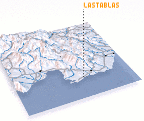 Places with similar names to Las Tablas, Dominican Republic ::
// Las Tablas (PA)
// Las Tablas (PA)
// Las Tablas (CU)
// Los Atabales (CU)
// Las Tablas (ES)
// Las Tablas (US)
// Las Tablas (CL)
// Las Tablas (SV)
// Las Tablas (SV)
// Las Tablas (SV)
Disclaimer :: Information on this page comes without warranty of any kind |
||
|
Where is Las Tablas? Elevation and coordinates ::
Latitude (lat): 18°17'0"N Longitude (lon): 70°24'0"W
Elevation (approx.): 84m (map arrows pan, magnifying glasses zoom) |
||
|
Visiting Las Tablas? Hotel/Accommodation ::
Book a hotel in Las Tablas Travel Guide ::
rental cars ::
car rental offers GPS waypoint ::
download a GPX waypoint (PoI) of Las Tablas for your GPS receiver
|
||