|
search place name
|
||
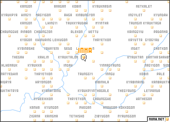
In-ma (Sagaing, Myanmar)In-ma is a town in the Sagaing region of Myanmar. An overview map of the region around In-ma is displayed below.
regional and 3d topo map of In-ma, Myanmar ::
In-ma airports ::
The nearest airport is IMF - Imphal, located 218.5 km north west of In-ma.
Other airports nearby include LSH - Lashio (221.7 km south east), MYT - Myitkyina (239.2 km north east), Nearby towns ::
Thaik-gyaung (1.7km east) //
Thabayagon (1.9km north) //
Letpangon (1.9km north) //
Naung-gaing (2.5km north west) //
Taunggyi (3.7km south) //
Myeni (3.4km west) //
Kyauktalon (3.4km west) //
Shangon (3.9km south east) //
Taungboksu (4.1km south east) //
Taungbaw (3.9km north east) //
Aunggyawgon (3.9km north east) //
In-gaw (3.9km south west) //
Sedo (3.9km north west) //
Thayetkon (5.0km north east) //
Nyaungdaung (5.0km north west) //
Didok (5.6km north) //
Myaunggyi (5.4km west) //
Yin-ma-gyaung (5.4km east) //
Wettu (5.8km north) //
Pazinda (5.8km north) //
Ale-kon (5.8km north) //
Inbinhla (6.5km south east) //
In-ngu (6.3km south east) //
Inbintha (6.3km north west) //
Leik-u-gon (6.3km north west) //
Taungbalu (7.4km south) //
Kani (7.4km south) //
Nga-pwegyi (6.8km west) //
Kyaukpyinthagale (7.6km south) //
[all distances 'as the bird flies' and approximate]  Places with similar names to In-ma, Myanmar ::
Disclaimer :: Information on this page comes without warranty of any kind |
||
|
Where is In-ma? Elevation and coordinates ::
Latitude (lat): 23°47'0"N Longitude (lon): 95°46'0"E
Elevation (approx.): 184m (map arrows pan, magnifying glasses zoom) |
||
|
Visiting In-ma? Hotel/Accommodation ::
Book a hotel in In-ma Travel Guide ::
Buy a travel guide for Myanmar rental cars ::
car rental offers GPS waypoint ::
download a GPX waypoint (PoI) of In-ma for your GPS receiver
|
||