|
search place name
|
||
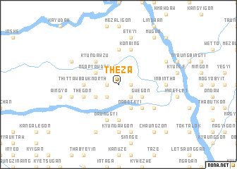
Theza (Sagaing, Myanmar)Theza is a town in the Sagaing region of Myanmar. An overview map of the region around Theza is displayed below.
regional and 3d topo map of Theza, Myanmar ::
Theza airports ::
The nearest airport is MDL - Mandalay Intl, located 162.7 km south east of Theza.
Other airports nearby include IMF - Imphal (240.3 km north west), Nearby towns ::
Sitsigon (1.7km west) //
Tasegye (1.7km east) //
Inna (2.5km north west) //
Pegon (2.5km south west) //
Nabetnge (2.5km south east) //
Wetmyedaw (3.9km north west) //
Ngapyawdaw (3.9km north west) //
Shun-aing (3.9km south west) //
Aungchantha (4.1km south east) //
Nabetkyi (4.1km south east) //
Ashetaik (4.1km south east) //
Gwegon (3.9km south east) //
Kyundawzu (5.0km north west) //
Ye-ugon (5.0km south east) //
Thittawbauk North (5.1km west) //
Peinnegon (5.6km south) //
Okpo-aing (5.6km south) //
Ywashe (5.6km north) //
Daunggyi (5.8km south) //
Nyaunggon (5.8km south) //
Hnangingyi (5.4km west) //
Thegon (5.4km west) //
Thittawbauk South (5.4km west) //
Kon-aing (5.8km north) //
Myauk-in (6.3km south east) //
Inbintha (6.8km east) //
Budaunggwe (7.4km south) //
Kyundawgon (7.4km south) //
Inkokka (7.6km south) //
[all distances 'as the bird flies' and approximate]  Places with similar names to Theza, Myanmar ::
Disclaimer :: Information on this page comes without warranty of any kind |
||
|
Where is Theza? Elevation and coordinates ::
Latitude (lat): 23°3'0"N Longitude (lon): 95°21'0"E
Elevation (approx.): 134m (map arrows pan, magnifying glasses zoom) |
||
|
Visiting Theza? Hotel/Accommodation ::
Book a hotel in Theza Travel Guide ::
Buy a travel guide for Myanmar rental cars ::
car rental offers GPS waypoint ::
download a GPX waypoint (PoI) of Theza for your GPS receiver
|
||