|
search place name
|
||
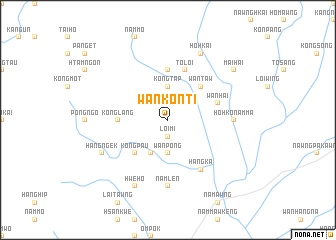
Wan Konti (Shan, Myanmar)Wan Konti is a town in the Shan region of Myanmar. An overview map of the region around Wan Konti is displayed below.
regional and 3d topo map of Wan Konti, Myanmar ::
Wan Konti airports ::
The nearest airport is HEH - Heho, located 131.7 km west of Wan Konti.
Other airports nearby include MOG - Mong Hsat (149.9 km south east), KET - Kengtung (172.4 km east), LSH - Lashio (203.8 km north), THL - Tachilek Tachileik (216.2 km east), Nearby towns ::
Loi-mi (1.9km south) //
Namhsu-ma-kāt (3.7km south) //
Wān Pong (3.7km south) //
Kongtap (3.7km north) //
Nawngsam (4.1km south west) //
Kongpau (5.1km south west) //
Wān Taw (5.1km north east) //
Konglang (5.2km west) //
Ho-pong (5.2km west) //
Nammawkan (5.6km north) //
Wān Hai (5.5km east) //
To-loi (5.8km north) //
Nā-pwe (5.8km north) //
Hai-lai (6.5km south east) //
Hangka (6.5km south east) //
Ho-hkö-namma (6.9km east) //
Namlen (7.4km south) //
Hangngek (7.8km south west) //
Hwè-ho (8.2km south west) //
Ho-hkai (8.2km north east) //
Mai-hai (8.9km north east) //
[all distances 'as the bird flies' and approximate]  Places with similar names to Wan Konti, Myanmar ::
// Winnecunnet (US)
// Wanakonde (NG)
// Wanikande (NG)
// Wanikanto (PG)
// Wān Kan Awt (MM)
// Wān Kè-inta (MM)
Disclaimer :: Information on this page comes without warranty of any kind |
||
|
Where is Wan Konti? Elevation and coordinates ::
Latitude (lat): 21°9'0"N Longitude (lon): 97°59'0"E
Elevation (approx.): 904m (map arrows pan, magnifying glasses zoom) |
||
|
Visiting Wan Konti? Hotel/Accommodation ::
Book a hotel in Wan Konti Travel Guide ::
Buy a travel guide for Myanmar rental cars ::
car rental offers GPS waypoint ::
download a GPX waypoint (PoI) of Wan Konti for your GPS receiver
|
||