|
search place name
|
||
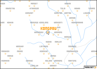
Kongpau (Shan, Myanmar)Kongpau is a town in the Shan region of Myanmar. An overview map of the region around Kongpau is displayed below.
regional and 3d topo map of Kongpau, Myanmar ::
Kongpau airports ::
The nearest airport is HEH - Heho, located 127.2 km west of Kongpau.
Other airports nearby include MOG - Mong Hsat (151.4 km south east), KET - Kengtung (176.2 km east), LSH - Lashio (207.1 km north), MDL - Mandalay Intl (214.5 km west), Nearby towns ::
Nawngsam (1.7km east) //
Wān Pong (3.5km east) //
Namhsu-ma-kāt (3.5km east) //
Hangngek (3.5km west) //
Hwè-ho (3.7km south) //
Loi-mi (3.9km north east) //
Ho-pong (4.1km north west) //
Konglang (4.1km north west) //
Wan Konti (5.1km north east) //
Namlen (5.1km south east) //
Lai-tawng (5.8km south) //
Pongngo (6.4km north west) //
Nawngwawn (7.4km south) //
Hai-lai (7.2km east) //
Hangka (7.2km east) //
Hsankwè (7.6km south) //
Kongtap (8.2km north east) //
Wān Taw (10.1km north east) //
Kongmot (10.1km north west) //
[all distances 'as the bird flies' and approximate] 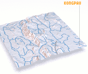 Places with similar names to Kongpau, Myanmar ::
Disclaimer :: Information on this page comes without warranty of any kind |
||
|
Where is Kongpau? Elevation and coordinates ::
Latitude (lat): 21°7'0"N Longitude (lon): 97°57'0"E
Elevation (approx.): 964m (map arrows pan, magnifying glasses zoom) |
||
|
Visiting Kongpau? Hotel/Accommodation ::
Book a hotel in Kongpau Travel Guide ::
Buy a travel guide for Myanmar rental cars ::
car rental offers GPS waypoint ::
download a GPX waypoint (PoI) of Kongpau for your GPS receiver
|
||