|
search place name
|
||
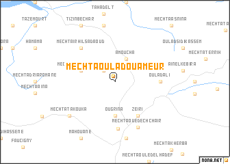
Mechta Oulad Ou Ameur (Sétif, Algeria)Mechta Oulad Ou Ameur is a town in the Sétif region of Algeria. An overview map of the region around Mechta Oulad Ou Ameur is displayed below.
regional and 3d topo map of Mechta Oulad Ou Ameur, Algeria ::
Mechta Oulad Ou Ameur airports ::
The nearest airport is BJA - Bejaja Soummam, located 49.9 km north west of Mechta Oulad Ou Ameur.
Other airports nearby include GJL - Jijel (65.1 km north east), CZL - Constantine Mohamed Boudiaf Intl (109.9 km east), BSK - Biskra (175.4 km south), Nearby towns ::
Mechta Oulad Morhem (2.4km north west) //
Amoucha (4.0km north) //
Ougrina (5.6km south) //
Mechta Ouled Ahmar (4.8km north west) //
Zeïri (6.3km south east) //
Oulad Ali (6.0km east) //
El Ouricia (7.6km south) //
Mechta Irhil Sadaoud (7.1km north west) //
Mechta Oued ech Chaïr (8.0km south) //
Mechta Takouka (8.2km south west) //
[all distances 'as the bird flies' and approximate]  Places with similar names to Mechta Oulad Ou Ameur, Algeria ::
// Mechta Ouled Ahmar (DZ)
// Mechta Ouled Amar (DZ)
// Mechta Ouled Amara (DZ)
// Mechta Ouled Amara (DZ)
Disclaimer :: Information on this page comes without warranty of any kind |
||
|
Where is Mechta Oulad Ou Ameur? Elevation and coordinates ::
Latitude (lat): 36°21'0"N Longitude (lon): 5°24'0"E
Elevation (approx.): 1145m (map arrows pan, magnifying glasses zoom) |
||
|
Visiting Mechta Oulad Ou Ameur? Hotel/Accommodation ::
Book a hotel in Mechta Oulad Ou Ameur Travel Guide ::
Buy a travel guide for Algeria rental cars ::
car rental offers GPS waypoint ::
download a GPX waypoint (PoI) of Mechta Oulad Ou Ameur for your GPS receiver
|
||