|
search place name
|
||
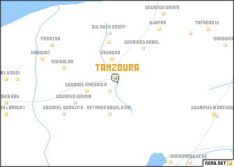
Tamzoura (Aïn Temouchent, Wilaya de, Algeria)Tamzoura is a town in the Aïn Temouchent, Wilaya de region of Algeria. An overview map of the region around Tamzoura is displayed below.
regional and 3d topo map of Tamzoura, Algeria ::
Tamzoura airports ::
The nearest airport is TAF - Oran Tafaraoui, located 18.5 km north east of Tamzoura.
Other airports nearby include ORN - Oran Es Senia (23.9 km north), MUW - Ghriss (76.4 km east), TLM - Tlemcen Zenata (84.5 km south west), OUD - Oujda Angads (134.7 km south west), Nearby towns ::
Douar Chaïba (1.5km south west) //
Kedadra (4.0km north) //
Metamer Abd el Arbi (5.0km south) //
Douar el Khedaïda (4.1km west) //
Choualia Fouaga (6.8km north) //
Domaine dʼArbal (6.6km north east) //
Douar Kouasmia (6.3km south west) //
Oulad Youssef (8.1km north) //
Sidi Salah (7.4km west) //
Douar el Ounazra (8.5km south west) //
Djafra (10.4km north east) //
[all distances 'as the bird flies' and approximate] 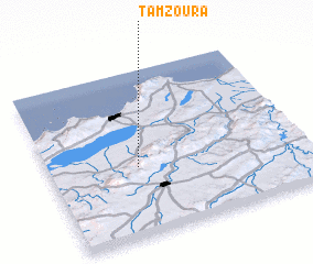 Places with similar names to Tamzoura, Algeria ::
Disclaimer :: Information on this page comes without warranty of any kind |
||
|
Where is Tamzoura? Elevation and coordinates ::
Latitude (lat): 35°24'38"N Longitude (lon): 0°39'22"W
Elevation (approx.): 184m (map arrows pan, magnifying glasses zoom) |
||
|
Visiting Tamzoura? Hotel/Accommodation ::
Book a hotel in Tamzoura Travel Guide ::
Buy a travel guide for Algeria rental cars ::
car rental offers GPS waypoint ::
download a GPX waypoint (PoI) of Tamzoura for your GPS receiver
|
||