|
search place name
|
||
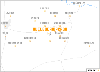
Núcleo Caio Prado (São Paulo, Brazil)Núcleo Caio Prado is a town in the São Paulo region of Brazil. An overview map of the region around Núcleo Caio Prado is displayed below.
regional and 3d topo map of Núcleo Caio Prado, Brazil ::
Núcleo Caio Prado airports ::
The nearest airport is QPS - Piracununga Campo Fontenelle, located 47.2 km north of Núcleo Caio Prado.
Other airports nearby include VCP - Campinas Viracopos (68.0 km south), POO - Pocos De Caldas (92.3 km north east), AQA - Araracuara Araraquara (113.4 km north west), GRU - Sao Paulo Guarulhos Gov Andre Franco Montouro (138.6 km south east), Nearby towns ::
Guaiquica (1.9km south) //
Marimbondo (2.5km north east) //
Reserva (3.4km east) //
Morro Grande (3.9km north east) //
Pântano (4.1km north west) //
São Vicente (5.0km north east) //
Conceição (5.5km east) //
Camacho (7.6km north) //
Bergamasco (7.1km west) //
Membeca (7.6km north west) //
Conchal (10.1km north east) //
[all distances 'as the bird flies' and approximate]  Places with similar names to Núcleo Caio Prado, Brazil :: Disclaimer :: Information on this page comes without warranty of any kind |
||
|
Where is Núcleo Caio Prado? Elevation and coordinates ::
Latitude (lat): 22°24'0"S Longitude (lon): 47°14'0"W
Elevation (approx.): 637m (map arrows pan, magnifying glasses zoom) |
||
|
Visiting Núcleo Caio Prado? Hotel/Accommodation ::
Book a hotel in Núcleo Caio Prado Travel Guide ::
Buy a travel guide for Brazil rental cars ::
car rental offers GPS waypoint ::
download a GPX waypoint (PoI) of Núcleo Caio Prado for your GPS receiver
|
||