|
search place name
|
||
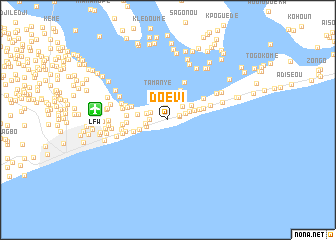
Doévi (Préfecture de Lomé, Togo)Doévi is a town in the Préfecture de Lomé region of Togo. An overview map of the region around Doévi is displayed below.
regional and 3d topo map of Doévi, Togo ::
Doévi airports ::
The nearest airport is LFW - Lome Gnassingbe Eyadema Intl, located 8.2 km west of Doévi.
Other airports nearby include COO - Cotonou Cadjehoun (119.1 km east), ACC - Accra Kotoka Intl (176.3 km west), LOS - Lagos Murtala Muhammed (225.5 km east), Nearby towns ::
Adjatogo (1.3km east) //
Baguida (1.4km north) //
Améwawou (1.4km east) //
Tokpokondji (2.0km west) //
Rhodan (2.1km north west) //
Agbosè (2.1km east) //
Avéfodzo (2.2km north east) //
Koumazan (2.3km north) //
Rhatosé (2.5km west) //
Oundo (2.5km west) //
Gbésogbé (2.5km west) //
Koudakpokomé (2.6km east) //
Foli Kopé (3.1km north east) //
Baka (3.1km east) //
Kokou Kopé (3.2km north) //
Tamanyé (3.2km north) //
Kawékondji (3.4km west) //
Kanyi (3.4km west) //
Lawadan (3.6km north) //
Séglo (3.7km east) //
Ayivi (4.1km west) //
Aményaglo (4.1km east) //
Kébolo (4.4km west) //
Dévégo (4.6km north east) //
Agodéké (4.6km north east) //
Ema Kopé (4.6km west) //
Kponou (4.6km west) //
Adakpamé (4.7km west) //
Lantigban (4.9km west) //
[all distances 'as the bird flies' and approximate] 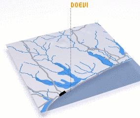 Places with similar names to Doévi, Togo ::
Disclaimer :: Information on this page comes without warranty of any kind |
||
|
Where is Doévi? Elevation and coordinates ::
Latitude (lat): 6°9'19"N Longitude (lon): 1°19'39"E
Elevation (approx.): -32768m (map arrows pan, magnifying glasses zoom) |
||
|
Visiting Doévi? Hotel/Accommodation ::
Book a hotel in Doévi Travel Guide ::
Buy a travel guide for Togo rental cars ::
car rental offers GPS waypoint ::
download a GPX waypoint (PoI) of Doévi for your GPS receiver
|
||