|
search place name
|
||
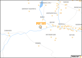
Paṯān (Paktīā, Afghanistan)Paṯān is a town in the Paktīā region of Afghanistan. An overview map of the region around Paṯān is displayed below.
regional and 3d topo map of Paṯān, Afghanistan ::
Paṯān airports ::
The nearest airport is JAA - Jalalabad, located 82.3 km north east of Paṯān.
Other airports nearby include KBL - Kabul Intl (106.7 km north west), PEW - Peshawar Intl (146.6 km east), Nearby towns ::
Kharlāchi (2.3km north east) //
Burgi (4.4km north) //
Kachkina (3.7km east) //
Bāzār (4.8km north east) //
Totak (4.9km east) //
Māta Sangar (5.4km south east) //
Bassu (5.5km east) //
Kanda (6.4km east) //
Japak Kili (6.5km east) //
Moqbal (7.8km south) //
Ghoz Garhi (7.1km south east) //
Karpurān Kili (7.5km north east) //
Ghulāmar Kili (6.8km east) //
Ghoz Garhi (7.5km south east) //
Ghulām Husain Kili (7.1km east) //
Darreh-ye Derang (9.4km north west) //
Murghai Kili (8.9km north east) //
Nare Kili (9.9km north east) //
Kara Khel (10.4km north east) //
[all distances 'as the bird flies' and approximate] 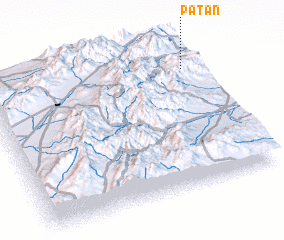 Places with similar names to Paṯān, Afghanistan ::
Disclaimer :: Information on this page comes without warranty of any kind |
||
|
Where is Paṯān? Elevation and coordinates ::
Latitude (lat): 33°49'11"N Longitude (lon): 69°56'36"E
Elevation (approx.): 1571m (map arrows pan, magnifying glasses zoom) |
||
|
Visiting Paṯān? Hotel/Accommodation ::
Book a hotel in Paṯān Travel Guide ::
Buy a travel guide for Afghanistan rental cars ::
car rental offers GPS waypoint ::
download a GPX waypoint (PoI) of Paṯān for your GPS receiver
|
||