|
search place name
|
||
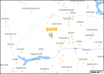
Quima (Malanje, Angola)Quima is a town in the Malanje region of Angola. An overview map of the region around Quima is displayed below.
regional and 3d topo map of Quima, Angola ::
Quima airports ::
The nearest airport is MEG - Malanje, located 14.7 km south of Quima.
Other airports nearby include GXG - Negage (211.5 km north west), UGO - Uige (241.0 km north west), Nearby towns ::
Ngumba (0.2km south west) //
Camueia Muhunzo (1.4km north west) //
Camatemo (4.0km north east) //
Catochi (4.6km south east) //
Mendonça (4.7km east) //
Pombo (5.5km north) //
Mbango (5.6km south east) //
Camambombo (6.3km east) //
Sona (6.7km south west) //
Chiguica (7.0km north) //
Nguvo (7.0km east) //
Gangassol (7.4km north) //
Ngumba (7.3km east) //
Chinguiça (7.4km north east) //
Lau (7.5km east) //
Cassucina (7.7km south east) //
Pedro Ulo (8.0km north east) //
Ngangassole II (8.2km north) //
Missáo do Quéssua (8.2km south) //
Caquiengue (9.2km south west) //
Manga (9.5km south east) //
Quimbamba (9.6km north east) //
Lau (9.9km south east) //
Nzambi iá Pungo (10.1km north east) //
Jimbo (10.8km north east) //
[all distances 'as the bird flies' and approximate]  Places with similar names to Quima, Angola ::
Disclaimer :: Information on this page comes without warranty of any kind |
||
|
Where is Quima? Elevation and coordinates ::
Latitude (lat): 9°24'0"S Longitude (lon): 16°16'0"E
Elevation (approx.): 1122m (map arrows pan, magnifying glasses zoom) |
||
|
Visiting Quima? Hotel/Accommodation ::
Book a hotel in Quima Travel Guide ::
Buy a travel guide for Angola rental cars ::
car rental offers GPS waypoint ::
download a GPX waypoint (PoI) of Quima for your GPS receiver
|
||