|
search place name
|
||
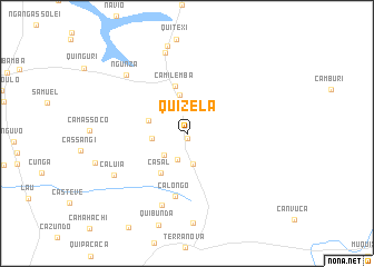
Quizela (Malanje, Angola)Quizela is a town in the Malanje region of Angola. An overview map of the region around Quizela is displayed below.
regional and 3d topo map of Quizela, Angola ::
Quizela airports ::
The nearest airport is MEG - Malanje, located 24.3 km south west of Quizela.
Other airports nearby include GXG - Negage (223.8 km north west), UGO - Uige (254.6 km north west), Nearby towns ::
Candende (0.6km south) //
Caingundo (2.3km north) //
Filipe Ribeiro (2.8km south) //
Cambaxi (3.2km south) //
Cajimbinza (3.2km south west) //
Catobuela (3.4km north) //
Camalanga Cambaxi (3.5km west) //
Cassembele (4.0km north) //
Camituto (4.0km west) //
Casal (4.7km south west) //
Camilemba (4.9km north) //
Calongo (6.4km south) //
Camuchi (7.6km south) //
Gunza-Muanha (8.4km north) //
Caluia (8.3km south west) //
Ngunza (8.4km north west) //
Quifucussa (8.9km north) //
[all distances 'as the bird flies' and approximate] 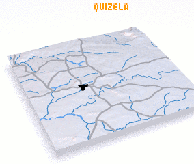 Places with similar names to Quizela, Angola ::
Disclaimer :: Information on this page comes without warranty of any kind |
||
|
Where is Quizela? Elevation and coordinates ::
Latitude (lat): 9°23'21"S Longitude (lon): 16°29'12"E
Elevation (approx.): 1194m (map arrows pan, magnifying glasses zoom) |
||
|
Visiting Quizela? Hotel/Accommodation ::
Book a hotel in Quizela Travel Guide ::
Buy a travel guide for Angola rental cars ::
car rental offers GPS waypoint ::
download a GPX waypoint (PoI) of Quizela for your GPS receiver
|
||