|
search place name
|
||
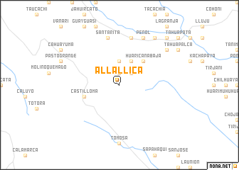
Allallica (La Paz, Bolivia)Allallica is a town in the La Paz region of Bolivia. An overview map of the region around Allallica is displayed below.
regional and 3d topo map of Allallica, Bolivia ::
Allallica airports ::
The nearest airport is LPB - La Paz El Alto Intl, located 39.8 km north west of Allallica.
Other airports nearby include CBB - Cochabamba Jorge Wilsterman (202.5 km east), Nearby towns ::
Ancosuni (1.9km north) //
Berenguela (1.9km north) //
Huaranca (2.6km north east) //
Chanca (3.7km north) //
Granjo (4.1km north east) //
Huaricana Baja (5.1km north east) //
Castilloma (5.6km west) //
Santa Rita (7.6km north) //
Huaricana (7.6km north) //
Peñol (8.2km north east) //
Challacirca (9.0km north east) //
Huaricana Baja (9.1km north east) //
Millucato (10.3km north east) //
[all distances 'as the bird flies' and approximate] 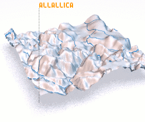 Places with similar names to Allallica, Bolivia ::
// Ālūlak (IR)
// Ailalec (TP)
// Alallaga (NE)
// Ali Lak (PK)
// Al ‘Ālūk (JO)
// Al ‘Ullayqah (SY)
// Al ‘Ullayqah (SY)
// Al ‘Allāqī (EG)
// Al ‘Ullayqah (LB)
// Al ‘Alaqah (SD)
Disclaimer :: Information on this page comes without warranty of any kind |
||
|
Where is Allallica? Elevation and coordinates ::
Latitude (lat): 16°48'0"S Longitude (lon): 67°58'0"W
Elevation (approx.): 3824m (map arrows pan, magnifying glasses zoom) |
||
|
Visiting Allallica? Hotel/Accommodation ::
Book a hotel in Allallica Travel Guide ::
Buy a travel guide for Bolivia rental cars ::
car rental offers GPS waypoint ::
download a GPX waypoint (PoI) of Allallica for your GPS receiver
|
||