|
search place name
|
||
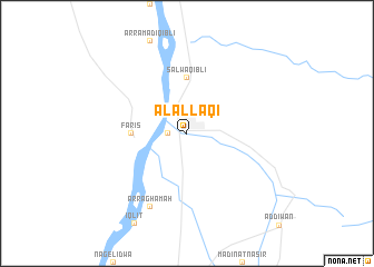
Al ‘Allāqī (Al Baḩr al Aḩmar, Egypt)Al ‘Allāqī is a town in the Al Baḩr al Aḩmar region of Egypt. An overview map of the region around Al ‘Allāqī is displayed below.
regional and 3d topo map of Al ‘Allāqī, Egypt ::
Al ‘Allāqī airports ::
The nearest airport is ASW - Aswan Intl, located 73.4 km south of Al ‘Allāqī.
Other airports nearby include LXR - Luxor Intl (119.3 km north), Nearby towns ::
Faţīrah (1.7km west) //
Salwá Qiblī (5.6km north) //
Fāris (5.1km west) //
Ar Raghāmah (8.1km south west) //
[all distances 'as the bird flies' and approximate] 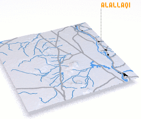 Places with similar names to Al ‘Allāqī, Egypt ::
// Allallica (BO)
// Ālūlak (IR)
// Ailalec (TP)
// Alallaga (NE)
// Ali Lak (PK)
// Al ‘Ālūk (JO)
// Al ‘Ullayqah (SY)
// Al ‘Ullayqah (SY)
// Al ‘Ullayqah (LB)
// Al ‘Alaqah (SD)
Disclaimer :: Information on this page comes without warranty of any kind |
||
|
Where is Al ‘Allāqī? Elevation and coordinates ::
Latitude (lat): 24°37'0"N Longitude (lon): 32°57'0"E
Elevation (approx.): 98m (map arrows pan, magnifying glasses zoom) |
||
|
Visiting Al ‘Allāqī? Hotel/Accommodation ::
Book a hotel in Al ‘Allāqī Travel Guide ::
Buy a travel guide for Egypt rental cars ::
car rental offers GPS waypoint ::
download a GPX waypoint (PoI) of Al ‘Allāqī for your GPS receiver
|
||