|
search place name
|
||
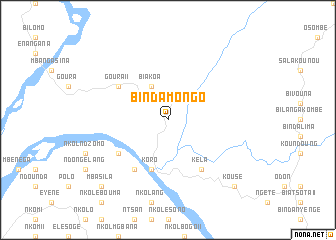
Bindamongo (Cameroon)Bindamongo is a town in Cameroon. An overview map of the region around Bindamongo is displayed below.
regional and 3d topo map of Bindamongo, Cameroon ::
Bindamongo airports ::
The nearest airport is YAO - Yaounde Ville, located 75.3 km south of Bindamongo.
Other airports nearby include FOM - Foumban Nkounja (149.2 km north west), BFX - Bafoussam (169.9 km north west), DLA - Douala (205.6 km west), BPC - Bamenda (227.3 km north west), Nearby towns ::
Biakoa (4.1km north west) //
Élang (5.9km south) //
Koro (5.9km south) //
Kokoé (6.7km south west) //
Kéla (6.7km south east) //
Goura II (6.7km north west) //
Biatingéna (6.7km north west) //
Nkolébasimbi (6.7km south west) //
Mbasila (10.5km south west) //
Kousé (10.5km south east) //
Bétamba (10.5km south east) //
[all distances 'as the bird flies' and approximate]  Places with similar names to Bindamongo, Cameroon ::
// Ban Na To Ming (TH)
// Ban Ta Miang (TH)
// Ban Ta Miang (TH)
// Ban Tamnak (TH)
// Ban Tamnak Kao (TH)
// Band-e Amnak (IR)
// Bontomanaik (ID)
// Ban Tambang (LA)
// Ban Tôming (LA)
// Bản Tam Bong (VN)
Disclaimer :: Information on this page comes without warranty of any kind |
||
|
Where is Bindamongo? Elevation and coordinates ::
Latitude (lat): 4°31'0"N Longitude (lon): 11°30'0"E
Elevation (approx.): 475m (map arrows pan, magnifying glasses zoom) |
||
|
Visiting Bindamongo? Hotel/Accommodation ::
Book a hotel in Bindamongo Travel Guide ::
Buy a travel guide for Cameroon rental cars ::
car rental offers GPS waypoint ::
download a GPX waypoint (PoI) of Bindamongo for your GPS receiver
|
||