|
search place name
|
||
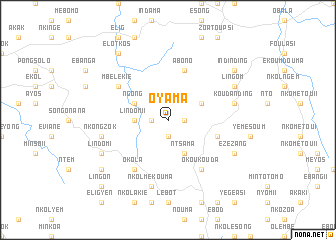
Oyama (Cameroon)Oyama is a town in Cameroon. An overview map of the region around Oyama is displayed below.
regional and 3d topo map of Oyama, Cameroon ::
Oyama airports ::
The nearest airport is YAO - Yaounde Ville, located 28.1 km south east of Oyama.
Other airports nearby include DLA - Douala (188.6 km west), FOM - Foumban Nkounja (188.7 km north west), BFX - Bafoussam (200.8 km north west), BMM - Bitam (220.3 km south), Nearby towns ::
Mvoua (1.8km east) //
Louma (1.8km west) //
Oban (1.9km south) //
Lindom II (3.7km west) //
Nkolndobo (4.1km north east) //
Ntsama (4.1km south east) //
Ngong (4.1km north west) //
Abono (5.9km north) //
Ékabita (5.8km east) //
Okoukouda (6.7km south east) //
Mbélékié (6.7km north west) //
Okola (6.7km south west) //
Koudanding (7.6km east) //
Nkolfep (7.6km east) //
Nkolmékouma (7.6km south) //
Nkongzok (7.6km west) //
Lingom (8.3km north east) //
Ézézang (8.3km south east) //
Lindom I (8.3km south west) //
Indinding (9.3km north east) //
Elotkos (9.3km north west) //
Ntouiesong (9.3km south west) //
Lingon (10.5km south west) //
[all distances 'as the bird flies' and approximate] 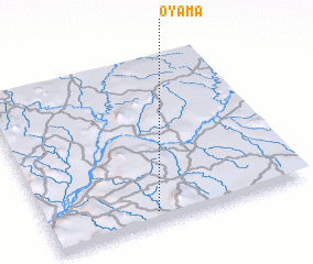 Places with similar names to Oyama, Cameroon ::
Disclaimer :: Information on this page comes without warranty of any kind |
||
|
Where is Oyama? Elevation and coordinates ::
Latitude (lat): 4°4'0"N Longitude (lon): 11°25'0"E
Elevation (approx.): 630m (map arrows pan, magnifying glasses zoom) |
||
|
Visiting Oyama? Hotel/Accommodation ::
Book a hotel in Oyama Travel Guide ::
Buy a travel guide for Cameroon rental cars ::
car rental offers GPS waypoint ::
download a GPX waypoint (PoI) of Oyama for your GPS receiver
|
||