|
search place name
|
||
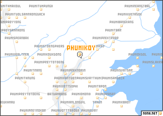
Phumĭ Kôy (Bătdâmbâng, Cambodia)Phumĭ Kôy is a town in the Bătdâmbâng region of Cambodia. An overview map of the region around Phumĭ Kôy is displayed below.
regional and 3d topo map of Phumĭ Kôy, Cambodia ::
Phumĭ Kôy airports ::
The nearest airport is REP - Siem-reap Siem Reap, located 66.0 km north east of Phumĭ Kôy.
Other airports nearby include NAK - Nakhon Ratchasima Khorat (231.4 km north west), PNH - Phnom-penh Phnom Penh Intl (250.7 km south east), Nearby towns ::
Phumĭ Rôhal Suŏng (1.8km east) //
Phumĭ Réach Don Kêv (2.6km north east) //
Phumĭ O Tôtœ̆ng (3.7km south) //
Phumĭ Prêk Chhdaô (4.1km south west) //
Phumĭ Bœ̆ng Krâsar (4.1km north east) //
Phumĭ O Don Chréab (4.1km north east) //
Phumĭ Prêk Kroch (4.1km south west) //
Phumĭ Prêk Nôrĭn (4.1km south west) //
Phumĭ Péam Êk (5.2km south west) //
Phumĭ Kông Tum (5.2km south west) //
Phumĭ Kâ Rôhal (5.7km west) //
Phumĭ Sna Pi Mŭk (1) (5.8km south) //
Phumĭ Svay Thum (2) (5.8km south) //
Phumĭ Sala Ta Ŏng (6.6km south west) //
Phumĭ Kântuŏt (6.6km south west) //
Phumĭ Kâm Prăk (6.6km north east) //
Phumĭ Prêk Troăp (6.6km north east) //
Phumĭ Koŭk Dong (7.2km west) //
Phumĭ Prey Tôtœ̆ng (7.5km west) //
Phumĭ Stœ̆ng Phéas (7.5km west) //
Phumĭ Băk Rôtéh (7.5km east) //
Phumĭ Don Téav (7.8km south west) //
Phumĭ Ta Pŏn (8.2km south east) //
Phumĭ Vôtt Nôréa (8.2km south west) //
Phumĭ Vôtt Sophi (8.2km south west) //
Phumĭ Âmpĭl Tœ̆k (8.1km north east) //
Phumĭ O Ta Pêk (8.1km north east) //
Phumĭ Poŭthĭ Mâ Srei (9.2km south west) //
Phumĭ O Krâsăng (9.2km south east) //
[all distances 'as the bird flies' and approximate]  Places with similar names to Phumĭ Kôy, Cambodia ::
// Vaymuga (RU)
// Vemaíika (GR)
// Fomka (RU)
// Phumĭ Kai (KH)
// Phumĭ Kaôh (KH)
// Phumĭ Kaôh (KH)
// Phumĭ Ké (KH)
// Phumĭ Ku (KH)
// Phumĭ O Kau (KH)
// Phumĭ O (2) (KH)
Disclaimer :: Information on this page comes without warranty of any kind |
||
|
Where is Phumĭ Kôy? Elevation and coordinates ::
Latitude (lat): 13°11'0"N Longitude (lon): 103°15'0"E
Elevation (approx.): 16m (map arrows pan, magnifying glasses zoom) |
||
|
Visiting Phumĭ Kôy? Hotel/Accommodation ::
Book a hotel in Phumĭ Kôy Travel Guide ::
Buy a travel guide for Cambodia rental cars ::
car rental offers GPS waypoint ::
download a GPX waypoint (PoI) of Phumĭ Kôy for your GPS receiver
|
||