|
search place name
|
||
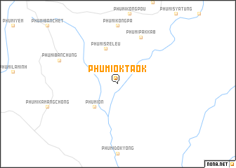
Phumĭ Ŏk Taôk (Rôtânăh Kiri, Cambodia)Phumĭ Ŏk Taôk is a town in the Rôtânăh Kiri region of Cambodia. An overview map of the region around Phumĭ Ŏk Taôk is displayed below.
regional and 3d topo map of Phumĭ Ŏk Taôk, Cambodia ::
Phumĭ Ŏk Taôk airports ::
The nearest airport is PKZ - Pakse, located 239.6 km north west of Phumĭ Ŏk Taôk.
Other airports nearby include NHA - Nhatrang (251.8 km south east), Nearby towns ::
Phumĭ Ŏn (5.2km south west) //
Kóng Khlŏng (5.8km north) //
Phumĭ Srê Leu (5.8km north) //
Phumĭ Pak Kâb (8.2km north east) //
[all distances 'as the bird flies' and approximate] 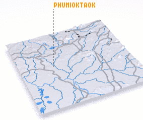 Places with similar names to Phumĭ Ŏk Taôk, Cambodia ::
Disclaimer :: Information on this page comes without warranty of any kind |
||
|
Where is Phumĭ Ŏk Taôk? Elevation and coordinates ::
Latitude (lat): 13°34'0"N Longitude (lon): 107°19'0"E
Elevation (approx.): 151m (map arrows pan, magnifying glasses zoom) |
||
|
Visiting Phumĭ Ŏk Taôk? Hotel/Accommodation ::
Book a hotel in Phumĭ Ŏk Taôk Travel Guide ::
Buy a travel guide for Cambodia rental cars ::
car rental offers GPS waypoint ::
download a GPX waypoint (PoI) of Phumĭ Ŏk Taôk for your GPS receiver
|
||