|
search place name
|
||
Phumĭ Prêk Sâmraông (Bătdâmbâng, Cambodia)Phumĭ Prêk Sâmraông is a town in the Bătdâmbâng region of Cambodia. An overview map of the region around Phumĭ Prêk Sâmraông is displayed below.
regional and 3d topo map of Phumĭ Prêk Sâmraông, Cambodia ::

Phumĭ Prêk Sâmraông airports ::
The nearest airport is REP - Siem-reap Siem Reap, located 91.7 km east of Phumĭ Prêk Sâmraông.
Other airports nearby include NAK - Nakhon Ratchasima Khorat (190.2 km north west), UTP - Rayong U Taphao Intl (229.2 km west), PNH - Phnom-penh Phnom Penh Intl (293.2 km south east), Nearby towns ::
Phumĭ Châk (1.9km north) //
Phumĭ Koŭk Pônléa (1.9km south) //
Phumĭ Châmkar Chék (2.6km south east) //
Phumĭ Dângkaô (1) (2.6km north east) //
Phumĭ Don Mul (2.6km north west) //
Phumĭ Srê Prey (3.7km south) //
Phumĭ Dâng Trang (3.7km south) //
Phumĭ Ta Bŭn (3.7km south) //
Phumĭ Ta Pŏk (3.7km south) //
Phumĭ Châmnaôm (3.6km west) //
Phumĭ Kâmping (4.1km south east) //
Phumĭ Krâmól (4.1km north east) //
Phumĭ Rôhăt Tœ̆k (4.1km north east) //
Phumĭ O Prasat (4.1km north east) //
Phumĭ Roŭng Koŭ Daeum (4.1km south west) //
Phumĭ Sakâr Svay (5.2km south east) //
Phumĭ Poŭthĭ Pĭr Daeum (5.2km north east) //
Phumĭ Ta Sál (5.2km south west) //
Phumĭ Baôs Ngĕn (5.2km south west) //
Phumĭ Bœ̆ng Trás (5.6km south) //
Phumĭ Tuŏl Nhung (5.6km south) //
Phumĭ O Snguŏt (5.7km east) //
Phumĭ Phnum Thum (5.7km east) //
Phumĭ Chuŏr Khchăs (5.8km south) //
Phumĭ Vôtt Thmei (6.6km south east) //
Phumĭ Kaông Kang (6.6km south east) //
Phumĭ Tŏl Bŏt (6.6km south east) //
Phumĭ Pôngrôr (1) (6.6km north east) //
Phumĭ Koŭk Tônloăb (6.6km north east) //
[all distances 'as the bird flies' and approximate] 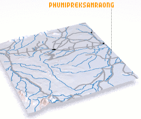 Places with similar names to Phumĭ Prêk Sâmraông, Cambodia :: Disclaimer :: Information on this page comes without warranty of any kind |
||
|
Where is Phumĭ Prêk Sâmraông? Elevation and coordinates ::
Latitude (lat): 13°27'0"N Longitude (lon): 102°58'0"E
Elevation (approx.): 15m (map arrows pan, magnifying glasses zoom) |
||
|
Visiting Phumĭ Prêk Sâmraông? Hotel/Accommodation ::
Book a hotel in Phumĭ Prêk Sâmraông Travel Guide ::
Buy a travel guide for Cambodia rental cars ::
car rental offers GPS waypoint ::
download a GPX waypoint (PoI) of Phumĭ Prêk Sâmraông for your GPS receiver
|
||