|
search place name
|
||
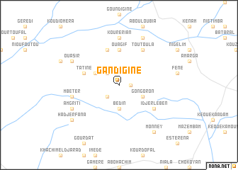
Gandiginé (Ouaddaï, Chad)Gandiginé is a town in the Ouaddaï region of Chad. An overview map of the region around Gandiginé is displayed below.
regional and 3d topo map of Gandiginé, Chad ::
Gandiginé airports ::
The nearest airport is AEH - Abeche, located 52.4 km north west of Gandiginé.
Nearby towns ::
Namouroum (1.8km east) //
Faral (2.6km north west) //
Kaméré (2.6km south west) //
Bédin (3.7km south) //
Koko (4.1km north west) //
Gongoron (4.1km south east) //
Ouagif (5.6km north) //
Tatiné (5.7km west) //
Katakar (5.8km north) //
Toutoula (6.6km north east) //
Idjerlében (6.6km south east) //
Kourérian (7.4km north) //
Mbéter (7.4km west) //
Ouasir (8.1km north west) //
Am Griti (8.1km south west) //
Am Chaloba (8.2km north east) //
Hadjer Fana (9.1km south west) //
Monney (9.2km south east) //
[all distances 'as the bird flies' and approximate] 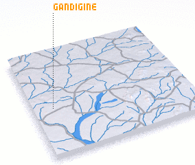 Places with similar names to Gandiginé, Chad ::
// Cantujaon (PH)
// Goundiginé (TD)
// Goundogin (TD)
// Gondeh Jīn (IR)
// Gondehjīn (IR)
// Cainatagen (PE)
// Candjane (MZ)
Disclaimer :: Information on this page comes without warranty of any kind |
||
|
Where is Gandiginé? Elevation and coordinates ::
Latitude (lat): 13°28'0"N Longitude (lon): 21°8'0"E
Elevation (approx.): 687m (map arrows pan, magnifying glasses zoom) |
||
|
Visiting Gandiginé? Hotel/Accommodation ::
Book a hotel in Gandiginé Travel Guide ::
Buy a travel guide for Chad rental cars ::
car rental offers GPS waypoint ::
download a GPX waypoint (PoI) of Gandiginé for your GPS receiver
|
||