|
search place name
|
||
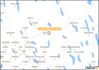
Médékourou (Kanem, Chad)Médékourou is a town in the Kanem region of Chad. An overview map of the region around Médékourou is displayed below.
regional and 3d topo map of Médékourou, Chad ::
Nearby towns ::
Bia (1.8km west) //
Oyoumbou (5.8km south) //
Youno (6.5km north west) //
Médi (7.6km south) //
Binda (7.7km south east) //
Koloum (8.1km south west) //
Koyo (9.2km south west) //
Billa (9.2km south west) //
Djougou II (9.1km south west) //
Torfé (9.1km north west) //
Maou (10.3km south east) //
[all distances 'as the bird flies' and approximate]  Places with similar names to Médékourou, Chad ::
// Moetagare (ZA)
// Matukuroa (NZ)
// Mat'-Gora (RU)
// Mitkirey (RU)
// Māitkora (BD)
// Mutakura (BI)
// Mutukura (BI)
// Madogoré (TD)
// Maïdougouri (TD)
// Médi Koura (TD)
Disclaimer :: Information on this page comes without warranty of any kind |
||
|
Where is Médékourou? Elevation and coordinates ::
Latitude (lat): 14°11'0"N Longitude (lon): 15°24'0"E
Elevation (approx.): 341m (map arrows pan, magnifying glasses zoom) |
||
|
Visiting Médékourou? Hotel/Accommodation ::
Book a hotel in Médékourou Travel Guide ::
Buy a travel guide for Chad rental cars ::
car rental offers GPS waypoint ::
download a GPX waypoint (PoI) of Médékourou for your GPS receiver
|
||