|
search place name
|
||
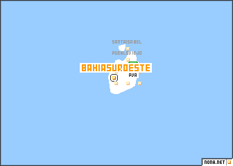
Bahía Suroeste (Providencia y Santa Catalina, Departamento de Archipiélago de San Andrés, Colombia)Bahía Suroeste is a town in the Providencia y Santa Catalina, Departamento de Archipiélago de San Andrés region of Colombia. An overview map of the region around Bahía Suroeste is displayed below.
regional and 3d topo map of Bahía Suroeste, Colombia ::
Bahía Suroeste airports ::
The nearest airport is PVA - Providencia El Embrujo, located 3.8 km north east of Bahía Suroeste.
Other airports nearby include ADZ - San Andres Island Gustavo Rojas Pinilla (90.3 km south west), Nearby towns ::
Casabaja (0.0km north) //
Bottom House (1.8km east) //
Lupton (1.8km east) //
Aguamansa (1.8km east) //
Ayacucho (1.9km north) //
Aguadulce (1.9km north) //
San Felipe (1.9km north) //
Bogotá (3.6km east) //
La Paz (3.6km east) //
Rocky Point (4.1km north east) //
El Valle (4.1km north east) //
Mountain (4.1km north east) //
Pueblo Viejo (4.1km north east) //
Santa Isabel (5.8km north) //
Jacob (5.8km north) //
Jones Point (5.8km north) //
[all distances 'as the bird flies' and approximate]  Places with similar names to Bahía Suroeste, Colombia :: Disclaimer :: Information on this page comes without warranty of any kind |
||
|
Where is Bahía Suroeste? Elevation and coordinates ::
Latitude (lat): 13°20'0"N Longitude (lon): 81°23'0"W
Elevation (approx.): 49m (map arrows pan, magnifying glasses zoom) |
||
|
Visiting Bahía Suroeste? Hotel/Accommodation ::
Book a hotel in Bahía Suroeste Travel Guide ::
Buy a travel guide for Colombia rental cars ::
car rental offers GPS waypoint ::
download a GPX waypoint (PoI) of Bahía Suroeste for your GPS receiver
|
||