|
search place name
|
||
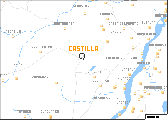
Castilla (Tolima, Colombia)Castilla is a town in the Tolima region of Colombia. An overview map of the region around Castilla is displayed below.
regional and 3d topo map of Castilla, Colombia ::
Castilla airports ::
The nearest airport is IBE - Ibague Perales, located 66.9 km north of Castilla.
Other airports nearby include NVA - Neiva Benito Salas (99.6 km south), AXM - Armenia El Eden (104.7 km north west), PEI - Pereira Matecana (132.8 km north west), ULQ - Tulua Farfan (133.3 km west), Nearby towns ::
Cascabel (4.5km south east) //
Jabalcón (6.7km north east) //
La Arenosa (6.9km south east) //
Media Luna (8.0km south west) //
Caserio El Redil (8.0km north east) //
Santa Marta (8.2km north west) //
Tierra Negra (8.5km north east) //
Chenche Asoleado (8.6km east) //
La María (8.8km north east) //
Buenos Aires (9.2km south east) //
Hacienda San Miguel (9.3km south east) //
Cabuyales (9.5km north east) //
Boca de Hilarco (10.6km south east) //
[all distances 'as the bird flies' and approximate] 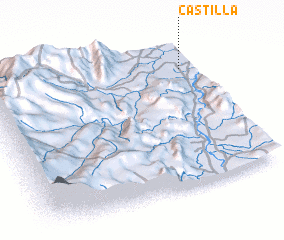 Places with similar names to Castilla, Colombia ::
Disclaimer :: Information on this page comes without warranty of any kind |
||
|
Where is Castilla? Elevation and coordinates ::
Latitude (lat): 3°49'15"N Longitude (lon): 75°3'52"W
Elevation (approx.): 317m (map arrows pan, magnifying glasses zoom) |
||
|
Visiting Castilla? Hotel/Accommodation ::
Book a hotel in Castilla Travel Guide ::
Buy a travel guide for Colombia rental cars ::
car rental offers GPS waypoint ::
download a GPX waypoint (PoI) of Castilla for your GPS receiver
|
||