|
search place name
|
||
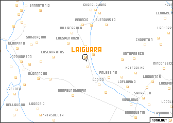
La Iguara (Departamento de Casanare, Colombia)La Iguara is a town in the Departamento de Casanare region of Colombia. An overview map of the region around La Iguara is displayed below.
regional and 3d topo map of La Iguara, Colombia ::
La Iguara airports ::
The nearest airport is VVC - Villavicencio Vanguardia, located 102.5 km south west of La Iguara.
Other airports nearby include BOG - Bogota Eldorado Intl (136.1 km west), TME - Tame (224.9 km north east), Nearby towns ::
Santa Rosita del Tua (1.2km south) //
La Palmita (2.1km north east) //
El Vergel (3.2km north west) //
Brisas del Llano (3.3km north) //
La Esperanza (5.6km north west) //
La Pica (5.7km south east) //
Palestina (6.0km south east) //
Villa Carola (7.0km north west) //
Los Carpatos (7.2km west) //
Las Delicias (7.7km east) //
El Berruguero (7.9km south east) //
La Rancherita (7.9km north) //
Venecia (8.0km north) //
San Pedro de Upía (8.0km south) //
La Vainilla (8.3km south east) //
Aguaclara (8.7km south west) //
Buenavista (9.1km north east) //
La Florida (10.4km south east) //
[all distances 'as the bird flies' and approximate] 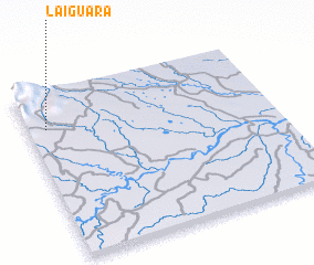 Places with similar names to La Iguara, Colombia ::
Disclaimer :: Information on this page comes without warranty of any kind |
||
|
Where is La Iguara? Elevation and coordinates ::
Latitude (lat): 4°47'1"N Longitude (lon): 72°55'23"W
Elevation (approx.): 325m (map arrows pan, magnifying glasses zoom) |
||
|
Visiting La Iguara? Hotel/Accommodation ::
Book a hotel in La Iguara Travel Guide ::
Buy a travel guide for Colombia rental cars ::
car rental offers GPS waypoint ::
download a GPX waypoint (PoI) of La Iguara for your GPS receiver
|
||