|
search place name
|
||
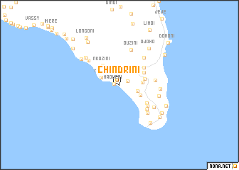
Chindrini (Anjouan, Comoros)Chindrini is a town in the Anjouan region of Comoros. An overview map of the region around Chindrini is displayed below.
regional and 3d topo map of Chindrini, Comoros ::
Chindrini airports ::
The nearest airport is AJN - Anjouan Ouani, located 20.8 km north of Chindrini.
Other airports nearby include NWA - Moheli Bandaressalam (75.8 km west), DZA - Dzaoudzi Pamandzi (104.0 km south east), HAH - Moroni Prince Said Ibrahim (156.0 km north west), Nearby towns ::
Maouéni (0.8km west) //
Kangani (1.4km north east) //
Daji (2.9km east) //
Moya (3.0km north west) //
Bandakouni (3.6km east) //
Mrijou (3.7km south east) //
Mrémani (4.0km east) //
Nkozini (4.0km north west) //
Jandza (4.2km north east) //
Adda-Douéni (4.6km north east) //
Mnazichoumoué (5.1km south east) //
Nounga (5.4km south east) //
Ongoujou (5.6km east) //
Outsa (5.7km north east) //
Chaouéni (5.7km south east) //
Ouzini (5.8km north) //
Koué (6.1km north west) //
Bouijou (6.2km south east) //
Kyo (6.3km east) //
Bouéjou (6.4km south east) //
Mirondoni (6.3km east) //
Magnassini-Nindri (6.7km north west) //
Pomoni (7.2km north west) //
Ajaho (7.3km north east) //
Salapouani (7.7km south east) //
Antsahé (7.8km south east) //
Mramani (7.8km south east) //
Bandamaji (8.0km south east) //
Lingoni (8.4km north west) //
[all distances 'as the bird flies' and approximate]  Places with similar names to Chindrini, Comoros ::
// Chāndarun (IN)
// Chandrāni (IN)
// Chandrāon (IN)
// Shendurni (IN)
// Chandrāin (PK)
// Chandrāni (PK)
// Chandrāni (PK)
// Chenʼ-Trenʼ (UA)
// Chandraghona (BD)
// Chantraine (FR)
Disclaimer :: Information on this page comes without warranty of any kind |
||
|
Where is Chindrini? Elevation and coordinates ::
Latitude (lat): 12°19'1"S Longitude (lon): 44°27'47"E
Elevation (approx.): 210m (map arrows pan, magnifying glasses zoom) |
||
|
Visiting Chindrini? Hotel/Accommodation ::
Book a hotel in Chindrini Travel Guide ::
Buy a travel guide for Comoros rental cars ::
car rental offers GPS waypoint ::
download a GPX waypoint (PoI) of Chindrini for your GPS receiver
|
||