|
search place name
|
||
Bamlūr (Jammu and Kashmīr, India)Bamlūr is a town in the Jammu and Kashmīr region of India. An overview map of the region around Bamlūr is displayed below.
regional and 3d topo map of Bamlūr, India ::

Bamlūr airports ::
The nearest airport is SXR - Srinagar, located 23.6 km south of Bamlūr.
Other airports nearby include RAZ - Rawala Kot Rawalakot (97.5 km south west), MFG - Muzaffarabad (116.9 km west), ISB - Islamabad Chaklala (167.2 km west), IXJ - Jammu (167.7 km south), Nearby towns ::
Fatehpura (0.5km south east) //
Sālūra (0.7km north west) //
Chak Fatehpura (1.2km north east) //
Haran (1.4km south) //
Gāndarbal (1.5km north) //
Dodarhāma (1.5km north) //
Katsan (1.4km south west) //
Kujar (1.5km south east) //
Gund Rahmān (1.7km south) //
Khan (1.7km south west) //
Hakīmgund (2.0km south west) //
Gangarhāma (2.2km north) //
Rāmpur (2.3km north west) //
Baihāma (2.3km north east) //
Patha Ārampura (2.6km north) //
Gādurāh (2.7km south east) //
Maishāhibāgh (2.6km north east) //
Malarpura (3.0km north) //
Wahidpur (3.0km north) //
Sindhbal (2.9km west) //
Ladwana (3.2km north west) //
Dhobipur (3.5km north) //
Dagpur (3.7km south) //
Darind (3.2km east) //
Skekhapur (3.3km west) //
Thūru (3.9km north) //
Tulamul (3.6km north west) //
Gāndarbal (4.0km north) //
Hatbur (3.6km south west) //
[all distances 'as the bird flies' and approximate] 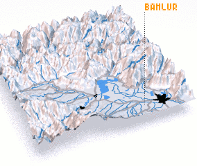 Places with similar names to Bamlūr, India ::
Disclaimer :: Information on this page comes without warranty of any kind |
||
|
Where is Bamlūr? Elevation and coordinates ::
Latitude (lat): 34°12'0"N Longitude (lon): 74°46'0"E
Elevation (approx.): 1584m (map arrows pan, magnifying glasses zoom) |
||
|
Visiting Bamlūr? Hotel/Accommodation ::
Book a hotel in Bamlūr Travel Guide ::
Buy a travel guide for India rental cars ::
car rental offers GPS waypoint ::
download a GPX waypoint (PoI) of Bamlūr for your GPS receiver
|
||