|
search place name
|
||
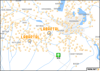
Labartal (Jammu and Kashmīr, India)Labartal is a town in the Jammu and Kashmīr region of India. An overview map of the region around Labartal is displayed below.
regional and 3d topo map of Labartal, India ::
Labartal airports ::
The nearest airport is SXR - Srinagar, located 7.9 km south of Labartal.
Other airports nearby include RAZ - Rawala Kot Rawalakot (90.5 km west), MFG - Muzaffarabad (118.3 km west), IXJ - Jammu (151.6 km south), ISB - Islamabad Chaklala (160.0 km west), Nearby towns ::
Bamhina (0.2km south east) //
Doru (0.6km south) //
Bimun (0.7km north east) //
Dundus (1.0km north west) //
Batahār (1.4km south) //
Sabdan (1.5km south west) //
Nārakur (1.6km south east) //
Chak Kāle Khān (1.5km south west) //
Rakhhakarmūla (1.5km west) //
Mohandpura (1.9km south) //
Chaudharibāgh (1.8km south west) //
Gulwānpur (1.9km west) //
Ompura (2.3km south) //
Hākarmul (2.1km north west) //
Rashipura (2.3km south west) //
Durabal (2.9km north) //
Gorteng (2.6km east) //
Hānjik (3.1km north) //
Shekhpur (3.2km south) //
Budan (2.8km south west) //
Wārpura (3.3km south) //
Sharīfābād (3.6km north) //
Gangabug (3.0km east) //
Haripura (3.0km west) //
Lālau Shisgaribāgh (3.0km east) //
Nārachpur (3.6km south) //
Warbpura (3.1km west) //
Mīragund (3.3km south west) //
Takipura (3.2km south west) //
[all distances 'as the bird flies' and approximate]  Places with similar names to Labartal, India ::
Disclaimer :: Information on this page comes without warranty of any kind |
||
|
Where is Labartal? Elevation and coordinates ::
Latitude (lat): 34°3'15"N Longitude (lon): 74°44'45"E
Elevation (approx.): 1590m (map arrows pan, magnifying glasses zoom) |
||
|
Visiting Labartal? Hotel/Accommodation ::
Book a hotel in Labartal Travel Guide ::
Buy a travel guide for India rental cars ::
car rental offers GPS waypoint ::
download a GPX waypoint (PoI) of Labartal for your GPS receiver
|
||