|
search place name
|
||
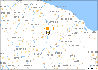
Kiara (Indonesia)Kiara is a town in Indonesia. An overview map of the region around Kiara is displayed below.
regional and 3d topo map of Kiara, Indonesia ::
Kiara airports ::
The nearest airport is CGK - Jakarta Soekarno Hatta Intl, located 95.2 km west of Kiara.
Nearby towns ::
Lemahabang (1.4km south west) //
Tanjung (1.8km south) //
Puloklapa (2.3km west) //
Bajur (2.8km north east) //
Pasirmaung (2.8km west) //
Turi (2.9km west) //
Puloparako (4.1km north) //
Gembongan (4.3km south east) //
Cikalong 1 (4.3km east) //
Puloluntas (4.4km north west) //
Puloputri (4.7km north east) //
Jungklohu (4.8km south east) //
Kalembuntu (4.9km east) //
Gadangmanggar (5.0km west) //
Caringin (5.2km south) //
Krasak (5.7km east) //
Cikalong 4 (5.8km south) //
Pulohaur 2 (5.7km north west) //
Wadas (5.9km west) //
Louweungwalang (6.3km west) //
Babawangan (6.3km west) //
Pasirukem (6.4km north east) //
Kosambilempeng (6.4km north east) //
Pacing (6.4km south) //
Sengon (6.7km west) //
Bengle (7.0km south east) //
Gipondok (7.3km south west) //
Cilamaya (7.4km east) //
Tegallurung (7.5km north east) //
[all distances 'as the bird flies' and approximate]  Places with similar names to Kiara, Indonesia ::
Disclaimer :: Information on this page comes without warranty of any kind |
||
|
Where is Kiara? Elevation and coordinates ::
Latitude (lat): 6°16'5"S Longitude (lon): 107°30'15"E
Elevation (approx.): 10m (map arrows pan, magnifying glasses zoom) |
||
|
Visiting Kiara? Hotel/Accommodation ::
Book a hotel in Kiara Travel Guide ::
Buy a travel guide for Indonesia rental cars ::
car rental offers GPS waypoint ::
download a GPX waypoint (PoI) of Kiara for your GPS receiver
|
||