|
search place name
|
||
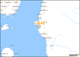
Loleo (Indonesia)Loleo is a town in Indonesia. An overview map of the region around Loleo is displayed below.
regional and 3d topo map of Loleo, Indonesia ::
Loleo airports ::
The nearest airport is TTE - Ternate Sultan Babullah, located 33.8 km north west of Loleo.
Other airports nearby include OTI - Morotai Island Pitu (185.8 km north east), Nearby towns ::
Juju (1.9km north) //
Sofang (1.9km east) //
Roi (2.6km north east) //
Sisimatio (2.6km north east) //
Akelamo (2.6km south east) //
Sosuo (3.7km north) //
Ditilau (3.7km north) //
Bula (4.1km north east) //
Todomito (4.1km south east) //
Masifo (5.2km south east) //
Bobo (5.6km north) //
Gumele (5.6km north) //
Marama-ake (6.7km south east) //
Gumi (6.7km south east) //
Tobobatu (7.6km north) //
[all distances 'as the bird flies' and approximate] 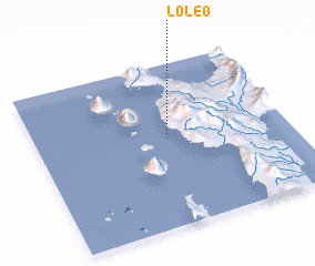 Places with similar names to Loleo, Indonesia ::
Disclaimer :: Information on this page comes without warranty of any kind |
||
|
Where is Loleo? Elevation and coordinates ::
Latitude (lat): 0°34'0"S Longitude (lon): 127°32'0"E
Elevation (approx.): -32768m (map arrows pan, magnifying glasses zoom) |
||
|
Visiting Loleo? Hotel/Accommodation ::
Book a hotel in Loleo Travel Guide ::
Buy a travel guide for Indonesia rental cars ::
car rental offers GPS waypoint ::
download a GPX waypoint (PoI) of Loleo for your GPS receiver
|
||