|
search place name
|
||
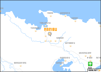
Maribu (Indonesia)Maribu is a town in Indonesia. An overview map of the region around Maribu is displayed below.
regional and 3d topo map of Maribu, Indonesia ::
Maribu airports ::
The nearest airport is DJJ - Jayapura Sentani, located 18.1 km south east of Maribu.
Other airports nearby include WMX - Wamena (239.1 km south west), Nearby towns ::
Kantome (1.9km west) //
Waibron-baru (1.9km south) //
Waibron-bano (1.9km south) //
Yangkena (1.9km south) //
Depapre (2.6km north west) //
Paipou (2.6km south west) //
Dazai (2.6km south east) //
Tablanusu (4.1km north west) //
Sabron (4.1km south east) //
Temingoh (5.9km west) //
Yaona (7.4km north) //
Doyobaru (8.3km south east) //
Doromena (9.3km north east) //
[all distances 'as the bird flies' and approximate] 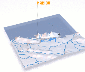 Places with similar names to Maribu, Indonesia ::
Disclaimer :: Information on this page comes without warranty of any kind |
||
|
Where is Maribu? Elevation and coordinates ::
Latitude (lat): 2°29'0"S Longitude (lon): 140°23'0"E
Elevation (approx.): 352m (map arrows pan, magnifying glasses zoom) |
||
|
Visiting Maribu? Hotel/Accommodation ::
Book a hotel in Maribu Travel Guide ::
Buy a travel guide for Indonesia rental cars ::
car rental offers GPS waypoint ::
download a GPX waypoint (PoI) of Maribu for your GPS receiver
|
||