|
search place name
|
||
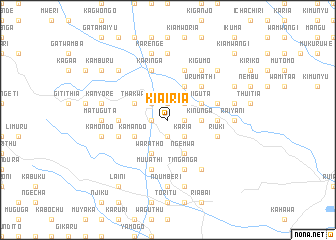
Kiairia (Central, Kenya)Kiairia is a town in the Central region of Kenya. An overview map of the region around Kiairia is displayed below.
regional and 3d topo map of Kiairia, Kenya ::
Kiairia airports ::
The nearest airport is WIL - Nairobi Wilson, located 26.4 km south of Kiairia.
Other airports nearby include EDL - Eldoret Intl (239.3 km north west), Nearby towns ::
Kanjai (1.9km north) //
Kianjogu (1.9km north) //
Kiangima (1.9km north) //
Gathanje (1.9km west) //
Ikinu (1.9km south) //
Giathieko (1.9km east) //
Gakoe (1.9km east) //
Giachumi (2.6km north west) //
Githamba (2.6km north east) //
Karia (2.6km south east) //
Kairi (3.7km east) //
Kinunga (3.7km east) //
Kimathi (3.7km east) //
Thakwa (4.1km north west) //
Miguta (4.1km north east) //
Kamando (4.1km south west) //
Karweti (4.1km north east) //
Kiambururu (4.1km north east) //
Waratho (4.1km south west) //
Ngemwa (4.1km south east) //
Gitombo (5.2km north east) //
Urumathi (5.2km north east) //
Kiratina (5.2km north east) //
Gituamba (5.6km west) //
Githinga B (5.6km west) //
Nyaga (5.6km east) //
Kambara (5.6km east) //
Mbari-ya-Igi (5.9km east) //
Gathanji (5.9km west) //
[all distances 'as the bird flies' and approximate]  Places with similar names to Kiairia, Kenya ::
Disclaimer :: Information on this page comes without warranty of any kind |
||
|
Where is Kiairia? Elevation and coordinates ::
Latitude (lat): 1°5'0"S Longitude (lon): 36°48'0"E
Elevation (approx.): 1811m (map arrows pan, magnifying glasses zoom) |
||
|
Visiting Kiairia? Hotel/Accommodation ::
Book a hotel in Kiairia Travel Guide ::
Buy a travel guide for Kenya rental cars ::
car rental offers GPS waypoint ::
download a GPX waypoint (PoI) of Kiairia for your GPS receiver
|
||