|
search place name
|
||
Kamsango (Ghana)Kamsango is a town in Ghana. An overview map of the region around Kamsango is displayed below.
regional and 3d topo map of Kamsango, Ghana ::

Kamsango airports ::
The nearest airport is TML - Tamale, located 160.5 km south of Kamsango.
Other airports nearby include OUA - Ouagadougou (187.9 km north west), LRL - Niatougou Niamtougou International (220.5 km south east), Nearby towns ::
Nosikluga (0.0km north) //
Kogo (1.8km west) //
Kubongo (2.6km north west) //
Kukurizoga (2.6km south west) //
Teshi (3.6km east) //
Goziesi (3.7km south) //
Bingo (4.1km north west) //
Abeu (4.1km south west) //
Bougouré (4.1km north east) //
Aronkpe (5.2km south west) //
Zawngo (5.2km north east) //
Lamboya (5.6km south) //
Yikurugu (5.5km east) //
Zebilla (5.7km south) //
Bezune (5.9km south) //
Wiere (5.8km west) //
Tampizalga (5.8km east) //
Widenaba (5.8km west) //
Zusablaga (5.9km north) //
Tiego (6.6km south east) //
Bazunde (7.6km south) //
Sakom (7.8km south east) //
Tampézi (7.8km north west) //
Zérébougou (8.2km north west) //
Alenzua (8.3km south west) //
Kuboko (8.3km south east) //
Zoaga (9.2km north west) //
Gango (9.2km north east) //
Sango (10.4km north east) //
[all distances 'as the bird flies' and approximate] 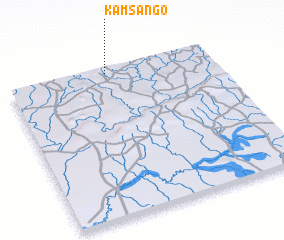 Places with similar names to Kamsango, Ghana ::
// Queimasangue (BR)
// Kamocinek (PL)
// Kumasinka (RU)
// Gombe-Isongo (CD)
// Kamba-Sengo (CD)
// Kamusenga (CD)
// Kamusenga (CD)
// Komsing (IN)
// Gua Musang (MY)
// Kamsenga (TZ)
Disclaimer :: Information on this page comes without warranty of any kind |
||
|
Where is Kamsango? Elevation and coordinates ::
Latitude (lat): 10°58'0"N Longitude (lon): 0°31'0"W
Elevation (approx.): 244m (map arrows pan, magnifying glasses zoom) |
||
|
Visiting Kamsango? Hotel/Accommodation ::
Book a hotel in Kamsango Travel Guide ::
Buy a travel guide for Ghana rental cars ::
car rental offers GPS waypoint ::
download a GPX waypoint (PoI) of Kamsango for your GPS receiver
|
||