|
search place name
|
||
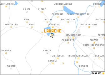
La Hache (Querétaro de Arteaga, Mexico)La Hache is a town in the Querétaro de Arteaga region of Mexico. An overview map of the region around La Hache is displayed below.
regional and 3d topo map of La Hache, Mexico ::
La Hache airports ::
The nearest airport is QRO - Queretaro Intercontinental, located 28.7 km north west of La Hache.
Other airports nearby include MLM - Morelia General Francisco J Mujica Intl (116.4 km south west), TLC - Toluca Licenciado Adolfo Lopez Mateos Intl (127.1 km south east), PCA - Pachuca Ingeniero Juan Guillermo Villasana (138.4 km east), MEX - Mexico City Licenciado Benito Juarez Intl (147.8 km south east), Nearby towns ::
La Estancia (3.7km north) //
Galindo (3.9km north west) //
La Venta del Refugio (5.2km east) //
San Jacinto (5.5km east) //
Casildo (5.8km south) //
Crucitas (5.8km north) //
San Juan del Río (6.9km east) //
Santa Lucía (7.6km south) //
San Germán (7.6km north) //
Santa Matilde (7.6km north east) //
Coto (7.9km north west) //
Caxuxi (12.1km south east) //
[all distances 'as the bird flies' and approximate] 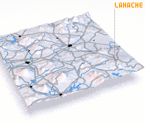 Places with similar names to La Hache, Mexico ::
Disclaimer :: Information on this page comes without warranty of any kind |
||
|
Where is La Hache? Elevation and coordinates ::
Latitude (lat): 20°23'0"N Longitude (lon): 100°4'0"W
Elevation (approx.): 1966m (map arrows pan, magnifying glasses zoom) |
||
|
Visiting La Hache? Hotel/Accommodation ::
Book a hotel in La Hache Travel Guide ::
Buy a travel guide for Mexico rental cars ::
car rental offers GPS waypoint ::
download a GPX waypoint (PoI) of La Hache for your GPS receiver
|
||