|
search place name
|
||
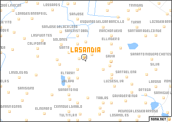
La Sandía (Guanajuato, Mexico)La Sandía is a town in the Guanajuato region of Mexico. An overview map of the region around La Sandía is displayed below.
regional and 3d topo map of La Sandía, Mexico ::
La Sandía airports ::
The nearest airport is BJX - Del Bajio Guanajuato Intl, located 22.7 km east of La Sandía.
Other airports nearby include AGU - Aguascalientes Jesus Teran Intl (109.4 km north west), ZMM - Zamora (114.6 km south west), MLM - Morelia General Francisco J Mujica Intl (136.6 km south east), QRO - Queretaro Intercontinental (159.4 km east), Nearby towns ::
Plan de Guanajuato (1.5km west) //
La Cinta (1.9km north east) //
San Rafael (2.5km south west) //
El Grangeno (3.9km south east) //
El Desagüe (4.1km north west) //
Santa Rita (3.9km north west) //
El Panal (4.1km south west) //
Plan Libertador (4.2km north) //
El Taray (5.1km south west) //
San Carlos del Jaguey (5.0km east) //
El Jaguey (5.1km east) //
Gavia (5.2km east) //
El Acebuche (5.4km west) //
Barretos (5.5km east) //
San Cristóbal (5.8km north) //
El Camaleón (6.0km south east) //
Jesús del Monte (5.9km west) //
Dolores (6.2km north west) //
El Lindero (6.4km north east) //
La Sardina (6.4km south east) //
El Tomate (6.6km south west) //
Jalapa (6.6km south west) //
Rancho Nuevo (7.6km north east) //
La Arcina (7.6km east) //
La Tuna Agria (8.1km south) //
Esquinas del Garbancillo (8.2km north east) //
San Antonio (8.2km south west) //
Luz de Silva (8.0km south east) //
San José de la Calera (8.2km north west) //
[all distances 'as the bird flies' and approximate]  Places with similar names to La Sandía, Mexico ::
Disclaimer :: Information on this page comes without warranty of any kind |
||
|
Where is La Sandía? Elevation and coordinates ::
Latitude (lat): 20°55'0"N Longitude (lon): 101°41'0"W
Elevation (approx.): 1762m (map arrows pan, magnifying glasses zoom) |
||
|
Visiting La Sandía? Hotel/Accommodation ::
Book a hotel in La Sandía Travel Guide ::
Buy a travel guide for Mexico rental cars ::
car rental offers GPS waypoint ::
download a GPX waypoint (PoI) of La Sandía for your GPS receiver
|
||