|
search place name
|
||
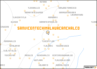
San Vicente Chimalhuacán Chalco (México, Mexico)San Vicente Chimalhuacán Chalco is a town in the México region of Mexico. An overview map of the region around San Vicente Chimalhuacán Chalco is displayed below.
regional and 3d topo map of San Vicente Chimalhuacán Chalco, Mexico ::
San Vicente Chimalhuacán Chalco airports ::
The nearest airport is PBC - Puebla Hermanos Serdan Intl, located 47.7 km east of San Vicente Chimalhuacán Chalco.
Other airports nearby include CVJ - Cuernavaca General Mariano Matamoros (52.6 km south west), MEX - Mexico City Licenciado Benito Juarez Intl (54.6 km north west), TXA - Tlaxcala (87.6 km north east), TLC - Toluca Licenciado Adolfo Lopez Mateos Intl (88.0 km north west), Nearby towns ::
Santiago Mamalhuazuca (1.9km south) //
Atlautla (1.8km east) //
Tepetlixpac (2.6km north west) //
Salida del Sol (2.6km south west) //
San Antonio Alzate (3.3km north east) //
Ozumba de Alzate (3.7km north) //
San Mateo Tecalco (3.7km north) //
Tlacotitlán (3.7km south) //
Texcaltitla (3.6km east) //
Loma Verde (4.2km south east) //
San Juan Tehuixtitlán (5.1km north east) //
Tlalamac (5.6km south) //
Guadalupe Hidalgo (5.7km south) //
Atlapango (5.6km west) //
San Esteban Cuecuecuautitla (5.6km west) //
Popo Park (5.8km north) //
San Juan Tepecoculco (5.7km south east) //
Las Delícias (6.1km north east) //
Nepantla de Sor Juana Inés de la Cruz (6.6km south west) //
San Antonio Zoyatzingo (7.6km north) //
Tecomaxusco (7.7km south east) //
San Matías Cuijingo (9.1km north west) //
San Diego Huehuecalco (10.2km north east) //
San Pedro Nexapa (10.2km north east) //
[all distances 'as the bird flies' and approximate]  Places with similar names to San Vicente Chimalhuacán Chalco, Mexico :: Disclaimer :: Information on this page comes without warranty of any kind |
||
|
Where is San Vicente Chimalhuacán Chalco? Elevation and coordinates ::
Latitude (lat): 19°1'0"N Longitude (lon): 98°48'0"W
Elevation (approx.): 2292m (map arrows pan, magnifying glasses zoom) |
||
|
Visiting San Vicente Chimalhuacán Chalco? Hotel/Accommodation ::
Book a hotel in San Vicente Chimalhuacán Chalco Travel Guide ::
Buy a travel guide for Mexico rental cars ::
car rental offers GPS waypoint ::
download a GPX waypoint (PoI) of San Vicente Chimalhuacán Chalco for your GPS receiver
|
||