|
search place name
|
||
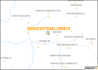
San Vicente del Zapote (Oaxaca, Mexico)San Vicente del Zapote is a town in the Oaxaca region of Mexico. An overview map of the region around San Vicente del Zapote is displayed below.
regional and 3d topo map of San Vicente del Zapote, Mexico ::
San Vicente del Zapote airports ::
The nearest airport is TCN - Tehuacan, located 136.5 km north east of San Vicente del Zapote.
Other airports nearby include CVJ - Cuernavaca General Mariano Matamoros (169.0 km north west), PBC - Puebla Hermanos Serdan Intl (171.8 km north), ACA - Acapulco General Juan N Alvarez Intl (180.0 km south west), OAX - Oaxaca Xoxocotlan Intl (181.4 km east), Nearby towns ::
Santiago Guadalupe (1.3km north) //
Huacapa (3.0km east) //
La Libertad (3.7km south west) //
San Juan Bautista Tlachichilco (6.0km south west) //
La Luz Tenexcalco (6.9km north) //
San Andrés Tepetlapa (7.7km west) //
San Miguel Ahuehuetitlán (8.2km north) //
Santiago Niño La Raya (8.2km south east) //
Santa Rosa de Juárez (8.4km east) //
Zapotitlán (9.0km north west) //
San José Sabinillo (9.0km south east) //
[all distances 'as the bird flies' and approximate] 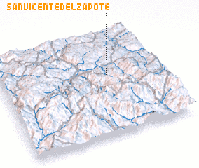 Places with similar names to San Vicente del Zapote, Mexico :: Disclaimer :: Information on this page comes without warranty of any kind |
||
|
Where is San Vicente del Zapote? Elevation and coordinates ::
Latitude (lat): 17°36'25"N Longitude (lon): 98°18'42"W
Elevation (approx.): 1374m (map arrows pan, magnifying glasses zoom) |
||
|
Visiting San Vicente del Zapote? Hotel/Accommodation ::
Book a hotel in San Vicente del Zapote Travel Guide ::
Buy a travel guide for Mexico rental cars ::
car rental offers GPS waypoint ::
download a GPX waypoint (PoI) of San Vicente del Zapote for your GPS receiver
|
||