|
search place name
|
||
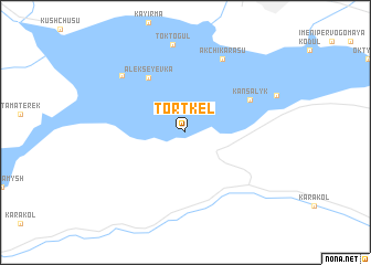
Tortkëlʼ (Kyrgyzstan)Tortkëlʼ is a town in Kyrgyzstan. An overview map of the region around Tortkëlʼ is displayed below.
regional and 3d topo map of Tortkëlʼ, Kyrgyzstan ::
Tortkëlʼ airports ::
The nearest airport is OSS - Osh, located 126.9 km south of Tortkëlʼ.
Other airports nearby include DMB - Dzhambul Taraz (177.9 km north west), FRU - Bishkek Manas (197.0 km north east), Nearby towns ::
Alekseyevka (6.2km north west) //
(( Kansalyk )) (5.8km north east) //
Akchikarasu (7.9km north) //
(( Ketmenʼtëbë )) (7.5km north west) //
(( Toktogul )) (8.9km north) //
[all distances 'as the bird flies' and approximate] 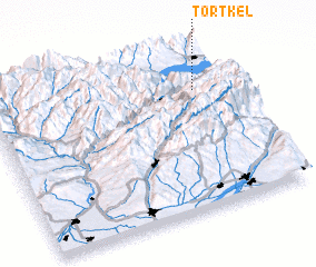 Places with similar names to Tortkëlʼ, Kyrgyzstan ::
// Tartagal (BO)
// Douar Doukkala (MA)
// Tortuguilla (PA)
// Tortuguilla (CU)
// Tardáguila (ES)
// Tortugal (CR)
// Törtköl (KZ)
// Törtköl (KZ)
// Tërt-Kul' (KG)
// Tŭrtkŭl (UZ)
Disclaimer :: Information on this page comes without warranty of any kind |
||
|
Where is Tortkëlʼ? Elevation and coordinates ::
Latitude (lat): 41°45'0"N Longitude (lon): 72°52'0"E
Elevation (approx.): 871m (map arrows pan, magnifying glasses zoom) |
||
|
Visiting Tortkëlʼ? Hotel/Accommodation ::
Book a hotel in Tortkëlʼ Travel Guide ::
Buy a travel guide for Kyrgyzstan rental cars ::
car rental offers GPS waypoint ::
download a GPX waypoint (PoI) of Tortkëlʼ for your GPS receiver
|
||