|
search place name
|
||
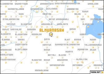
Al Muʼānasah (Liban-Nord, Lebanon)Al Muʼānasah is a town in the Liban-Nord region of Lebanon. An overview map of the region around Al Muʼānasah is displayed below.
regional and 3d topo map of Al Muʼānasah, Lebanon ::
Al Muʼānasah airports ::
The nearest airport is LTK - Latakia Bassel Al Assad Intl, located 97.3 km north west of Al Muʼānasah.
Other airports nearby include BEY - Beirut Rafic Hariri Intl (119.5 km south west), DAM - Damascus Intl (132.5 km south), PMS - Palmyra (177.5 km east), ALP - Aleppo Intl (191.3 km north east), Nearby towns ::
Al Buwayt (1.5km east) //
Qinyā (2.4km south west) //
Qal‘at al Burj (2.4km north west) //
Al Ḩamrāʼ (3.7km north) //
Wādī Khālid (4.0km north) //
Kafr Tūn (4.0km south) //
Marāḩ al Khawkh (3.6km south west) //
Marāḩ al Basātīn (3.6km south west) //
Al Muqaybilah (4.8km north west) //
Biznāyā (4.8km north east) //
Umm al Mays (4.8km north east) //
As Sahlah (4.6km west) //
Ash Shaykh Ibrāhīm (5.6km north) //
Marāsīyah (5.6km north) //
Ba‘yūn (5.6km north) //
Akrūm (5.8km south) //
Ḩunaydir (4.9km east) //
Al Hīt (4.9km east) //
Jiwā al ‘Arab (5.9km north west) //
Mushayrifat al Jabal (6.3km north west) //
Mashtá Ḩammūd (5.9km north west) //
Mcheïrefé see Mushayrifat al Jabal (6.3km north west) //
Summāqīyāt al Gharbīyah (5.9km south east) //
Umm ad Dawālī (6.3km north east) //
Ḩadīdah (7.4km north) //
Bayt ‘Alī (7.4km south) //
‘Ayn at Tīnah ash Sharqīyah (7.4km north) //
Mashtá Ḩasan (6.4km west) //
Shadrah (6.4km west) //
[all distances 'as the bird flies' and approximate]  Places with similar names to Al Muʼānasah, Lebanon ::
Disclaimer :: Information on this page comes without warranty of any kind |
||
|
Where is Al Muʼānasah? Elevation and coordinates ::
Latitude (lat): 34°36'0"N Longitude (lon): 36°23'0"E
Elevation (approx.): 486m (map arrows pan, magnifying glasses zoom) |
||
|
Visiting Al Muʼānasah? Hotel/Accommodation ::
Book a hotel in Al Muʼānasah Travel Guide ::
Buy a travel guide for Lebanon rental cars ::
car rental offers GPS waypoint ::
download a GPX waypoint (PoI) of Al Muʼānasah for your GPS receiver
|
||