|
search place name
|
||
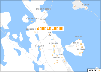
Jabal al Qawm (Saudi Arabia)Jabal al Qawm is a town in Saudi Arabia. An overview map of the region around Jabal al Qawm is displayed below.
regional and 3d topo map of Jabal al Qawm, Saudi Arabia ::
Jabal al Qawm airports ::
The nearest airport is DMM - Dammam King Fahd Intl, located 23.3 km south west of Jabal al Qawm.
Other airports nearby include DHA - Dhahran King Abdulaziz Ab (41.4 km south east), BAH - Bahrain Intl (75.1 km south east), LEA - Al-ahsa Al Ahsa (154.3 km south), DOH - Doha Intl (217.8 km south east), Nearby towns ::
Al ‘Awāmīyah (1.6km south east) //
Qudayḩ (3.9km south) //
Al Qudayḩ (4.2km south) //
At Tūbī (5.4km south) //
Şafwá (5.6km north west) //
Al Khatayshīyah (5.4km west) //
Al Awjām (5.8km south west) //
Khuwaylīdīyah (6.1km south) //
Jarūdīyah (7.1km south) //
Ḩillat Muḩīsh (7.7km south) //
Umm as Sāhik (8.2km north west) //
‘Ank (8.8km south east) //
Imhaish (8.8km south east) //
‘Ayn ash Shaqab (9.0km north) //
[all distances 'as the bird flies' and approximate] 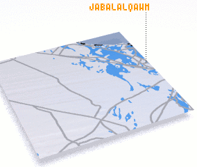 Places with similar names to Jabal al Qawm, Saudi Arabia :: Disclaimer :: Information on this page comes without warranty of any kind |
||
|
Where is Jabal al Qawm? Elevation and coordinates ::
Latitude (lat): 26°36'18"N Longitude (lon): 49°58'41"E
Elevation (approx.): 10m (map arrows pan, magnifying glasses zoom) |
||
|
Visiting Jabal al Qawm? Hotel/Accommodation ::
Book a hotel in Jabal al Qawm Travel Guide ::
rental cars ::
car rental offers GPS waypoint ::
download a GPX waypoint (PoI) of Jabal al Qawm for your GPS receiver
|
||