|
search place name
|
||
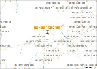
Kampong Baning (Negeri Sembilan, Malaysia)Kampong Baning is a town in the Negeri Sembilan region of Malaysia. An overview map of the region around Kampong Baning is displayed below.
regional and 3d topo map of Kampong Baning, Malaysia ::
Kampong Baning airports ::
The nearest airport is KUL - Kuala Lumpur Intl, located 50.8 km west of Kampong Baning.
Other airports nearby include MKZ - Malacca (56.4 km south), DUM - Dumai Pinang Kampai (151.8 km south west), KUA - Kuantan (160.8 km north east), JHB - Johor Bahru Sultan Ismail (208.4 km south east), Nearby towns ::
Kampong Ulu Gelugor (1.9km north) //
Kampong Gayet (1.9km north) //
Kampong Geyet (1.9km north) //
Kampong Purgong (1.9km east) //
Kampong Telang (1.9km east) //
Kampong Kok (2.6km north east) //
Kampong Jeram (2.6km north west) //
Kampong Rumali (2.6km south east) //
Kampong Mempas Kechil (2.6km south west) //
Kampong Ayer Hitam (2.6km south west) //
Kampong Bukit Melintang (3.7km west) //
Kampong Belayat (3.7km west) //
Kampong Durian Hijau (3.7km west) //
Kampong Tebing Tinggi (3.7km south) //
Kampong Ibol (3.7km south) //
Kampong Kundangan (4.1km south west) //
Kampong Ulu Mempas (4.1km south west) //
Kampong Pauh (4.1km south west) //
Kampong Mempas Besar (4.1km south west) //
Kampong Kuala Parit (4.1km south west) //
Kampong Parit Tengah (4.1km south west) //
Kampong Parit (4.1km south west) //
Kampong Tanjong Ipoh (5.2km south east) //
Ayer Sejok (5.2km south west) //
Kampong Padang Lebar (5.2km south west) //
Ulu Bendol New Village (5.2km south west) //
Kampong Panglang (5.9km south) //
Kampong Tengah (5.9km south) //
Kampong Ulu Parit (5.9km south) //
[all distances 'as the bird flies' and approximate]  Places with similar names to Kampong Baning, Malaysia ::
// Kampong Binong (MY)
Disclaimer :: Information on this page comes without warranty of any kind |
||
|
Where is Kampong Baning? Elevation and coordinates ::
Latitude (lat): 2°46'0"N Longitude (lon): 102°10'0"E
Elevation (approx.): 100m (map arrows pan, magnifying glasses zoom) |
||
|
Visiting Kampong Baning? Hotel/Accommodation ::
Book a hotel in Kampong Baning Travel Guide ::
Buy a travel guide for Malaysia rental cars ::
car rental offers GPS waypoint ::
download a GPX waypoint (PoI) of Kampong Baning for your GPS receiver
|
||