|
search place name
|
||
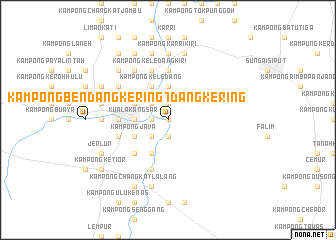
Kampong Bendang Kering (Perak, Malaysia)Kampong Bendang Kering is a town in the Perak region of Malaysia. An overview map of the region around Kampong Bendang Kering is displayed below.
regional and 3d topo map of Kampong Bendang Kering, Malaysia ::
Kampong Bendang Kering airports ::
The nearest airport is IPH - Ipoh Sultan Azlan Shah, located 26.0 km south east of Kampong Bendang Kering.
Other airports nearby include PEN - Penang Intl (96.4 km north west), AOR - Alor Setar Sultan Abdul Halim (169.5 km north), NAW - Narathiwat (212.1 km north east), KBR - Kota Bahru Sultan Ismail Petra (213.5 km north east), Nearby towns ::
Kampong Lembah (0.0km north) //
Kampong Pauh (1.9km north) //
Kampong Kapala Bendang (1.9km north) //
Kampong Kota Lama Kanan (1.9km north) //
Kampong Chermin (1.9km south) //
Kampong Padang Changkat (1.9km south) //
Kampong Jenalik (1.8km west) //
Kampong Tambang (1.8km west) //
Kampong Jias (2.6km north west) //
Kampong Sayong (2.6km north west) //
Kampong Kandang (2.6km north west) //
Kampong Penaga (2.6km north west) //
Kampong Pasong (2.6km north west) //
Kampong Parit (2.6km north west) //
Kampong Senawar (2.6km south west) //
Kampong Sungai Siput (2.6km south west) //
Kampong Pasir Batang Kulim (3.7km north) //
Kampong Padang Petai (3.7km north) //
Kuala Kangsar (3.7km west) //
Kampong Keledang (4.1km north west) //
Kampong Mesjid (4.1km north west) //
Kampong Lasin (4.1km north west) //
Kampong Kuala Chempelas (4.1km north west) //
Kampong Tanah Lepan (4.1km south west) //
Kampong Java (4.1km south west) //
Kampong Langkap (5.2km south west) //
Kampong Batang Kulim (5.6km north) //
Kampong Talang Ulu (5.5km west) //
Kampong Talang Masjid (5.5km west) //
[all distances 'as the bird flies' and approximate]  Places with similar names to Kampong Bendang Kering, Malaysia ::
// Kampong Bendang Kabu (MY)
// Kampong Bendang Keladi (MY)
// Kampong Bendang Kering (MY)
// Kampong Bendang Kering (MY)
Disclaimer :: Information on this page comes without warranty of any kind |
||
|
Where is Kampong Bendang Kering? Elevation and coordinates ::
Latitude (lat): 4°46'0"N Longitude (lon): 100°58'0"E
Elevation (approx.): 42m (map arrows pan, magnifying glasses zoom) |
||
|
Visiting Kampong Bendang Kering? Hotel/Accommodation ::
Book a hotel in Kampong Bendang Kering Travel Guide ::
Buy a travel guide for Malaysia rental cars ::
car rental offers GPS waypoint ::
download a GPX waypoint (PoI) of Kampong Bendang Kering for your GPS receiver
|
||