|
search place name
|
||
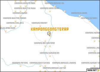
Kampong Gong Terap (Terengganu, Malaysia)Kampong Gong Terap is a town in the Terengganu region of Malaysia. An overview map of the region around Kampong Gong Terap is displayed below.
regional and 3d topo map of Kampong Gong Terap, Malaysia ::
Kampong Gong Terap airports ::
The nearest airport is TGG - Kuala Terengganu Sultan Mahmud, located 29.6 km east of Kampong Gong Terap.
Other airports nearby include KBR - Kota Bahru Sultan Ismail Petra (99.0 km north west), KTE - Kerteh (121.1 km south east), NAW - Narathiwat (169.0 km north west), KUA - Kuantan (191.2 km south), Nearby towns ::
Kampong Bukit Tanah Merah (0.0km north) //
Kampong Bukit Tok Ak (0.0km north) //
Kampong Kubang Puyu (1.9km north) //
Kampong Lubok Panjang (2.6km south west) //
Kampong Sungai Rakit (3.7km south) //
Kampong Lerek (3.7km south) //
Kampong Batu Hampar (4.1km south west) //
Kampung Hulu Caluk (4.1km south west) //
Kampung Rahmat (5.2km north west) //
Kampong Sungai Bari (7.4km south) //
[all distances 'as the bird flies' and approximate] 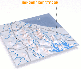 Places with similar names to Kampong Gong Terap, Malaysia ::
// Kampong Gong Terap (MY)
Disclaimer :: Information on this page comes without warranty of any kind |
||
|
Where is Kampong Gong Terap? Elevation and coordinates ::
Latitude (lat): 5°28'0"N Longitude (lon): 102°51'0"E
Elevation (approx.): 16m (map arrows pan, magnifying glasses zoom) |
||
|
Visiting Kampong Gong Terap? Hotel/Accommodation ::
Book a hotel in Kampong Gong Terap Travel Guide ::
Buy a travel guide for Malaysia rental cars ::
car rental offers GPS waypoint ::
download a GPX waypoint (PoI) of Kampong Gong Terap for your GPS receiver
|
||