|
search place name
|
||
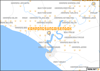
Kampong Sungai Sendok (Johor, Malaysia)Kampong Sungai Sendok is a town in the Johor region of Malaysia. An overview map of the region around Kampong Sungai Sendok is displayed below.
regional and 3d topo map of Kampong Sungai Sendok, Malaysia ::
Kampong Sungai Sendok airports ::
The nearest airport is MKZ - Malacca, located 39.4 km north west of Kampong Sungai Sendok.
Other airports nearby include KUL - Kuala Lumpur Intl (119.1 km north west), JHB - Johor Bahru Sultan Ismail (132.8 km south east), DUM - Dumai Pinang Kampai (137.3 km south west), XSP - Singapore Seletar (163.3 km south east), Nearby towns ::
Kampong Jalan Tok Raja (1.9km east) //
Kampong Tanjong Temiang (1.9km east) //
Kampong Telok Kemang (1.9km east) //
Kampong Pantai Layang (1.9km north) //
Kampong Parit Bunga (1.9km west) //
Kampong Pergam (2.6km north east) //
Kampong Jalan Kimkee (2.6km south east) //
Pt Bunga (2.6km south west) //
Kampong Tanjong Gading (3.7km west) //
Kampong Naib Pe'i (4.1km south east) //
Kampong Kesang (4.1km north west) //
Bunga Parit (4.1km south west) //
Kampong Tasek (5.2km north west) //
Sungai Mati (5.6km north) //
Kampung Tanjung Agas (5.6km south) //
Kampong Parit Lanjut (5.9km east) //
Kampong Terus (5.9km west) //
Kampong Pelampong (5.9km north) //
Kampong Tanjong Selabu (6.7km north east) //
Kampong Sungai Keladi (6.7km north east) //
Kampong Tengah (6.7km north east) //
Kampong Parit Perawas (6.7km north west) //
Kampong Telok Bakong (6.7km north east) //
Kampong Tengah (6.7km south east) //
Kampong Telok Gong (6.7km north west) //
Bukit Pasir (7.4km east) //
Kampong Parit Kangkar (7.4km north) //
Muar (7.4km south) //
Kampong Serpang (7.6km east) //
[all distances 'as the bird flies' and approximate]  Places with similar names to Kampong Sungai Sendok, Malaysia ::
// Kampong Sungai Sendok (MY)
// Kampong Sungai Sentang (MY)
Disclaimer :: Information on this page comes without warranty of any kind |
||
|
Where is Kampong Sungai Sendok? Elevation and coordinates ::
Latitude (lat): 2°6'0"N Longitude (lon): 102°34'0"E
Elevation (approx.): 8m (map arrows pan, magnifying glasses zoom) |
||
|
Visiting Kampong Sungai Sendok? Hotel/Accommodation ::
Book a hotel in Kampong Sungai Sendok Travel Guide ::
Buy a travel guide for Malaysia rental cars ::
car rental offers GPS waypoint ::
download a GPX waypoint (PoI) of Kampong Sungai Sendok for your GPS receiver
|
||