|
search place name
|
||
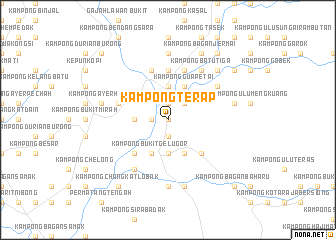
Kampong Terap (Perak, Malaysia)Kampong Terap is a town in the Perak region of Malaysia. An overview map of the region around Kampong Terap is displayed below.
regional and 3d topo map of Kampong Terap, Malaysia ::
Kampong Terap airports ::
The nearest airport is PEN - Penang Intl, located 46.3 km west of Kampong Terap.
Other airports nearby include IPH - Ipoh Sultan Azlan Shah (83.3 km south east), AOR - Alor Setar Sultan Abdul Halim (113.9 km north), LGK - Pulau Langkawi Intl (163.7 km north west), PAN - Pattani (182.9 km north), Nearby towns ::
Kampong Sungai Semut (0.0km north) //
Kampong Limau (1.8km west) //
Kampong Gua Bergambar (1.8km west) //
Kampong Banggol Rashid (1.9km north) //
Kampong Sungai Jambu (1.9km south) //
Kampong Gudang (1.9km north) //
Kampong Menteri Road (2.6km north east) //
Selama (2.6km north east) //
Kampong Batu Lintang (3.7km west) //
Kampong Kuala Selama (3.7km north) //
Kubu Gajah (3.7km south) //
Kampong Sungai Ayer Hitam (3.7km north) //
Kampong Medan (3.7km north) //
Kampong Bukit Gelugor (4.1km south west) //
Kampong Lembah Keluang (4.1km south west) //
Kampong Bukit Bertingkat (4.1km south east) //
Kampong Gua Petai (4.1km north east) //
Kampong Tengkolok Jatoh (5.2km south west) //
Kampong Baharu Sungai Dendang (5.2km south east) //
Kampong Paya Deras (5.6km north) //
Kampong Kuala Dingin (5.6km north) //
Kampong Seribu Relong (5.9km north) //
Kampong Sungai Salleh (5.8km west) //
Kampong Pechah Batu (5.8km west) //
Changkat Jenehing (5.9km north) //
Kampong Tebing Tinggi (6.7km south west) //
Kampong Tengah (6.7km north east) //
Rantau Panjang (6.7km north east) //
Kampong Medan (6.7km north east) //
[all distances 'as the bird flies' and approximate] 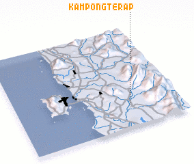 Places with similar names to Kampong Terap, Malaysia ::
// Kampong Tarrap (MY)
// Kampong Terap (MY)
// Kampong Terap (MY)
// Kampong Terap (MY)
// Kampong Terap (MY)
// Kampong Terap (MY)
// Kampong Terap (MY)
Disclaimer :: Information on this page comes without warranty of any kind |
||
|
Where is Kampong Terap? Elevation and coordinates ::
Latitude (lat): 5°12'0"N Longitude (lon): 100°41'0"E
Elevation (approx.): 19m (map arrows pan, magnifying glasses zoom) |
||
|
Visiting Kampong Terap? Hotel/Accommodation ::
Book a hotel in Kampong Terap Travel Guide ::
Buy a travel guide for Malaysia rental cars ::
car rental offers GPS waypoint ::
download a GPX waypoint (PoI) of Kampong Terap for your GPS receiver
|
||