|
search place name
|
||
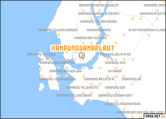
Kampung Damar Laut (Perak, Malaysia)Kampung Damar Laut is a town in the Perak region of Malaysia. An overview map of the region around Kampung Damar Laut is displayed below.
regional and 3d topo map of Kampung Damar Laut, Malaysia ::
Kampung Damar Laut airports ::
The nearest airport is IPH - Ipoh Sultan Azlan Shah, located 61.9 km north east of Kampung Damar Laut.
Other airports nearby include PEN - Penang Intl (122.4 km north), KUL - Kuala Lumpur Intl (204.9 km south east), AOR - Alor Setar Sultan Abdul Halim (216.1 km north), MES - Medan Polonia (230.9 km west), Nearby towns ::
Kampong Selangor (1.8km west) //
Kampong Tanjong Batu (1.8km west) //
Lumut (1.9km south) //
Kampong Pak Melan (1.8km east) //
Kampong Sungai Sempit (2.6km north west) //
Kampong Tebing Rabak (3.7km south) //
Kampong Batu Tiga (3.7km north) //
Kampong Kuala Sempit (3.7km west) //
Kampong Batu Undan (4.1km north east) //
Kampong Pasir Anging (4.1km south west) //
Kampong Telok Perepat (4.1km south west) //
Kampong Telok Kupia (4.1km north west) //
Kampong Bakar Bata (4.1km south east) //
Kampong Lalang (4.1km north east) //
Kampung Gajah Mati (4.1km north east) //
Kampong Batu Gajah (5.2km south west) //
Kampong Sungai Sitiawan (5.5km east) //
Kampong Balek Beting (5.8km west) //
Kampung Sungai Pinang Kecil (5.8km west) //
Kampong Pundut (5.9km south) //
Kampong Lumut Kiri (6.7km south east) //
Kampung Sungai Pinang Besar (6.7km south west) //
Kampung Bahru (6.7km north east) //
Kampung Baharu (6.7km north east) //
Kampong Batu Tiga (6.7km south east) //
Kampong Telok Chempadak (7.4km west) //
Kampong Deralik (7.4km east) //
Kampung Sitiawan (7.4km east) //
Kampong Jelutong (7.4km east) //
[all distances 'as the bird flies' and approximate] 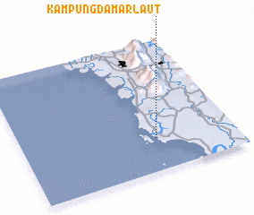 Places with similar names to Kampung Damar Laut, Malaysia :: Disclaimer :: Information on this page comes without warranty of any kind |
||
|
Where is Kampung Damar Laut? Elevation and coordinates ::
Latitude (lat): 4°15'0"N Longitude (lon): 100°38'0"E
Elevation (approx.): 2m (map arrows pan, magnifying glasses zoom) |
||
|
Visiting Kampung Damar Laut? Hotel/Accommodation ::
Book a hotel in Kampung Damar Laut Travel Guide ::
Buy a travel guide for Malaysia rental cars ::
car rental offers GPS waypoint ::
download a GPX waypoint (PoI) of Kampung Damar Laut for your GPS receiver
|
||