|
search place name
|
||
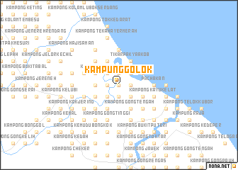
Kampung Golok (Kelantan, Malaysia)Kampung Golok is a town in the Kelantan region of Malaysia. An overview map of the region around Kampung Golok is displayed below.
regional and 3d topo map of Kampung Golok, Malaysia ::
Kampung Golok airports ::
The nearest airport is KBR - Kota Bahru Sultan Ismail Petra, located 40.9 km north west of Kampung Golok.
Other airports nearby include TGG - Kuala Terengganu Sultan Mahmud (86.0 km south east), NAW - Narathiwat (110.4 km north west), KTE - Kerteh (178.9 km south east), PAN - Pattani (179.9 km north west), Nearby towns ::
Kampong Bukit Kechik (0.0km north) //
Kampong Telok Lubok (1.8km west) //
Kampong Tanjong (1.8km west) //
Kampong Puyu (1.9km south) //
Kampong Ketik Buloh (1.9km north) //
Kampong Beris Tok Kambing (1.9km north) //
Kampong Bukit Peraksi (1.9km north) //
Kampong Beris Chalok (1.8km east) //
Kampong Gajah Mati (1.8km east) //
Kampong Tok Luchar (2.6km south west) //
Kampong Gong To' Din (2.6km south west) //
Kampong Besar (2.6km north west) //
Kampong Ketik Nangka (2.6km north west) //
Kampong Pengkalan Pauh (2.6km north west) //
Kampong Lembah (2.6km north west) //
Kampong Sepulai (2.6km north west) //
Kampong Pengkalan Sena (2.6km north west) //
Kampong Raja Dagang (2.6km north east) //
Kampong Sungai Selok (2.6km north east) //
Kampong Gong Manak (2.6km south east) //
Kampong Tok Janggut (2.6km north east) //
Kampung Cerang Ruku (2.6km north east) //
Kampong Kuala Semerak (2.6km north east) //
Padang Gong Palas (3.7km west) //
Kampong Baroh Derham (3.7km west) //
Kampong Gong Depu (4.1km south west) //
Kampong Gong Kemudu (4.1km south west) //
Kampung Gong Tapang (4.1km south west) //
Kampong Siam (4.1km north west) //
[all distances 'as the bird flies' and approximate]  Places with similar names to Kampung Golok, Malaysia ::
// Kampong Lagau (MY)
// Kampong Laka (MY)
// Kampong Lakau (MY)
// Kampong Lakau (MY)
// Kampong Laku (MY)
// Kampong Lik (MY)
// Kampong Liku (MY)
// Kampong Luak (MY)
// Kampong Lugu (MY)
// Kampong Lugu (MY)
Disclaimer :: Information on this page comes without warranty of any kind |
||
|
Where is Kampung Golok? Elevation and coordinates ::
Latitude (lat): 5°51'0"N Longitude (lon): 102°29'0"E
Elevation (approx.): 4m (map arrows pan, magnifying glasses zoom) |
||
|
Visiting Kampung Golok? Hotel/Accommodation ::
Book a hotel in Kampung Golok Travel Guide ::
Buy a travel guide for Malaysia rental cars ::
car rental offers GPS waypoint ::
download a GPX waypoint (PoI) of Kampung Golok for your GPS receiver
|
||