|
search place name
|
||
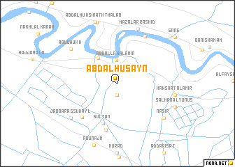
‘Abd al Ḩusayn (Wāsiţ, Iraq)‘Abd al Ḩusayn is a town in the Wāsiţ region of Iraq. An overview map of the region around ‘Abd al Ḩusayn is displayed below.
regional and 3d topo map of ‘Abd al Ḩusayn, Iraq ::
‘Abd al Ḩusayn airports ::
The nearest airport is KSH - Bakhtaran Shahid Ashrafi Esfahani, located 250.6 km north east of ‘Abd al Ḩusayn.
Nearby towns ::
Al Jawb (1.2km north) //
‘Ājil al Bāshī (1.9km south) //
‘Abd Allāh al Amīr (3.7km north) //
Muḩammad al Amīr (4.9km north west) //
Sulţān (6.7km south) //
Al Amīr (7.6km south) //
Al Ḩājj Şaḩn (7.2km south west) //
Umm al Banīn (8.4km north east) //
Jabbār as Suhayl (8.4km south west) //
Abū Dhukh (8.4km north west) //
Nāşir (8.4km south east) //
Maz‘al ar Rashīd (9.2km north) //
[all distances 'as the bird flies' and approximate]  Places with similar names to ‘Abd al Ḩusayn, Iraq ::
// Abdalhasan (TR)
// ‘Abd al Ḩasan (IQ)
// ‘Abd al Ḩassūn (IQ)
// ‘Abd al Ḩusayn (IQ)
// ‘Abd al Ḩusayn (IQ)
// ‘Abd al Ḩusayn (IQ)
// ‘Abd al Ḩusayn (IQ)
// ‘Abd al Ḩusayn (IQ)
// ‘Abd ol Ḩoseyn (IR)
Disclaimer :: Information on this page comes without warranty of any kind |
||
|
Where is ‘Abd al Ḩusayn? Elevation and coordinates ::
Latitude (lat): 32°29'0"N Longitude (lon): 45°38'0"E
Elevation (approx.): 21m (map arrows pan, magnifying glasses zoom) |
||
|
Visiting ‘Abd al Ḩusayn? Hotel/Accommodation ::
Book a hotel in ‘Abd al Ḩusayn Travel Guide ::
Buy a travel guide for Iraq rental cars ::
car rental offers GPS waypoint ::
download a GPX waypoint (PoI) of ‘Abd al Ḩusayn for your GPS receiver
|
||