|
search place name
|
||
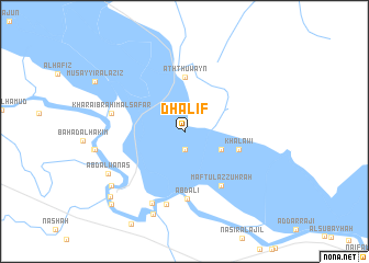
Dhalif (Al Muthanná, Iraq)Dhalif is a town in the Al Muthanná region of Iraq. An overview map of the region around Dhalif is displayed below.
regional and 3d topo map of Dhalif, Iraq ::
Nearby towns ::
Masīr al Ḩarbī (1.9km south) //
Jīfah (3.7km south east) //
Ath Thuwayn (5.6km north) //
Khalāwī (5.1km east) //
Maftūl az Zuhrah (6.4km south east) //
‘Abd ‘Alī (6.9km south) //
Kharāʼib Raḩīm Āl Safar (6.6km west) //
Ḩafīz̧ah (7.6km south) //
Khuḑayr Āl Yūnus (7.8km south) //
‘Abd Āl Wanās (7.9km south west) //
Munaysh (8.9km south) //
Ţurayţish Āl Ḩabīb (8.4km south west) //
Āl Dulākh (8.4km south west) //
Al Khiḑr (9.2km south west) //
Al Ḩājj Mahdī Āl ‘Ubayd (9.8km south west) //
Manīhamīl (9.8km south west) //
[all distances 'as the bird flies' and approximate]  Places with similar names to Dhalif, Iraq ::
// Deh-e ‘Alavī (IR)
// Dhelfoí (GR)
Disclaimer :: Information on this page comes without warranty of any kind |
||
|
Where is Dhalif? Elevation and coordinates ::
Latitude (lat): 31°16'0"N Longitude (lon): 45°37'0"E
Elevation (approx.): 10m (map arrows pan, magnifying glasses zoom) |
||
|
Visiting Dhalif? Hotel/Accommodation ::
Book a hotel in Dhalif Travel Guide ::
Buy a travel guide for Iraq rental cars ::
car rental offers GPS waypoint ::
download a GPX waypoint (PoI) of Dhalif for your GPS receiver
|
||